IMAGES TAKEN NEAR TO
Lansdales Road, HIGH WYCOMBE, HP11 2PB
Introduction
This page details the photographs taken nearby to Lansdales Road, HP11 2PB by members of the Geograph project.
The Geograph project started in 2005 with the aim of publishing, organising and preserving representative images for every square kilometre of Great Britain, Ireland and the Isle of Man.

There are currently over 7.5m images from over14,400 individuals and you can help contribute to the project by visiting https://www.geograph.org.uk
Image Map
Images are licensed for reuse under creativecommons.org/licenses/by-sa/2.0
Notes
- Clicking on the map will re-center to the selected point.
- The higher the marker number, the further away the image location is from the centre of the postcode.
Image Listing (44 Images Found)
Images are licensed for reuse under creativecommons.org/licenses/by-sa/2.0
Image
Details
Distance
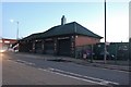
1
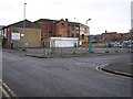
Baker Street & Short Street corner
Run-down area of High Wycombe HP11 2RX
Image: © Rob Emms
Taken: 11 Dec 2011
0.03 miles
2
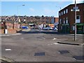
Desborough Avenue
Road junction: Desborough Avenue, looking north from Desborough Road.
Image: © Rob Emms
Taken: 11 Mar 2012
0.04 miles
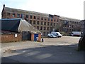
3
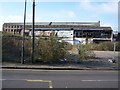
Derelict factory site
Leigh Street derelict old factories or warehouses: looking from Desborough Road.
Image: © Rob Emms
Taken: 11 Mar 2012
0.13 miles
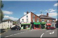
6
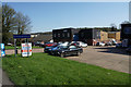
Marlborough Trading Estate
A commercial area off West Wycombe Road.
Image: © Bill Boaden
Taken: 20 Apr 2018
0.14 miles
7
Disused factory
One of the last old derelict factories in High Wycombe. Viewed from rear of Leigh Street.
Image: © Rob Emms
Taken: 11 Mar 2012
0.14 miles
8
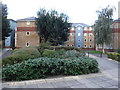
High Wycombe : Student Accommodation
Accommodation for the students of the nearby Bucks Uni.
Image: © Lewis Clarke
Taken: 9 Oct 2016
0.16 miles
9
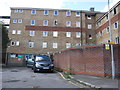
High Wycombe : Student Accommodation
From the back it looks almost like a prison.
Image: © Lewis Clarke
Taken: 9 Oct 2016
0.16 miles
10
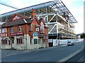
Eden Shopping Development
The Rose and Crown over shadowed by the new shopping centre
Image: © Peter Jemmett
Taken: 8 Oct 2006
0.17 miles