IMAGES TAKEN NEAR TO
Queen Alexandra Road, HIGH WYCOMBE, HP11 2GZ
Introduction
This page details the photographs taken nearby to Queen Alexandra Road, HP11 2GZ by members of the Geograph project.
The Geograph project started in 2005 with the aim of publishing, organising and preserving representative images for every square kilometre of Great Britain, Ireland and the Isle of Man.

There are currently over 7.5m images from over14,400 individuals and you can help contribute to the project by visiting https://www.geograph.org.uk
Image Map (Loading...)


Getting Data...Please wait
Leaflet Map data © OpenStreetMap
Images are licensed for reuse under creativecommons.org/licenses/by-sa/2.0
Notes
- Clicking on the map will re-center to the selected point.
- The higher the marker number, the further away the image location is from the centre of the postcode.
Image Listing (316 Images Found)
Images are licensed for reuse under creativecommons.org/licenses/by-sa/2.0
Image
Details
Distance
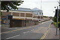

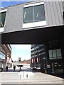
6
Lily's Walk
A link road to the raised A40.
Image: © Bill Boaden
Taken: 20 Apr 2018
0.07 miles
7
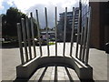
High Wycombe : Buckinghamshire New University - Woodworkers? ?Bodger?s Stand?
A charity sculpture of a Bodger's Stand celebrating High Wycombe's furniture history, supported by Hyundai Motor UK, and designed by a student.
Image: © Lewis Clarke
Taken: 9 Oct 2016
0.07 miles
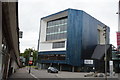
8
High Wycombe : Buckinghamshire New University
A paved area through the university.
Image: © Lewis Clarke
Taken: 9 Oct 2016
0.07 miles