IMAGES TAKEN NEAR TO
Oxford Street, HIGH WYCOMBE, HP11 2DJ
Introduction
This page details the photographs taken nearby to Oxford Street, HP11 2DJ by members of the Geograph project.
The Geograph project started in 2005 with the aim of publishing, organising and preserving representative images for every square kilometre of Great Britain, Ireland and the Isle of Man.

There are currently over 7.5m images from over14,400 individuals and you can help contribute to the project by visiting https://www.geograph.org.uk
Image Map
Images are licensed for reuse under creativecommons.org/licenses/by-sa/2.0
Notes
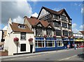
- Clicking on the map will re-center to the selected point.
- The higher the marker number, the further away the image location is from the centre of the postcode.
Image Listing (395 Images Found)
Images are licensed for reuse under creativecommons.org/licenses/by-sa/2.0
Image
Details
Distance
1
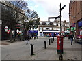
High Wycombe : Oxford Street
Looking along a pedestrianised road.
Image: © Lewis Clarke
Taken: 9 Oct 2016
0.01 miles
3
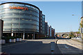
Arch Way, High Wycombe
The A4128 passing through the town centre. The Sainsbury's car park is dominant. The Chiltern Line crosses the road on a long viaduct, of which part is seen here.
Image: © Bill Boaden
Taken: 20 Apr 2018
0.03 miles
4
High Wycombe
Looking along Frogmoor, from Oxford Road, towards the railway viaduct.
Image: © Peter Trimming
Taken: 23 Mar 2016
0.04 miles
5
High Wycombe: Butlers
The National Heritage website map places a triangle in the centre of this group of buildings in Frogmoor and then describes the structure thus:-
"Early C19 or late C18 front to house incorporating earlier structure. Stucco, machine tiles. 2 storeys and attic, modern box dormer. Sash in reveal with glazing bars, ground floor cambered arch. Plain doorhood."
So evidently the listing applies to the small house on the left and not the much larger multi-storeyed half-timbered and more eye-catching edifice on the right that is the Butlers public house. The pub is owned by Marston's and its website is here http://www.butlerspub.co.uk/ One on the house next time?
Image: © Nigel Cox
Taken: 25 Jul 2015
0.04 miles
6
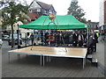
Mayor Making Platform, High Wycombe
This photo shows the platform, chair and weighing scales in Frogmoor awaiting the arrival of the new Mayor of High Wycombe and his officers for them to be weighed in. The annual custom dates back to medieval times and is unique to this Buckinghamshire market town. It takes place in Frogmoor on the third Saturday in May commencing at 11.45am.
Image: © David Hillas
Taken: 20 May 2017
0.04 miles
7
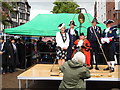
Mayor Making Ceremony, High Wycombe (2)
This photo shows the new Mayor of High Wycombe being weighed in, with the Lady Mayoress on the left. The Mayor and the Corporation of High Wycombe are weighed in today in full view of the public to see whether or not they have been getting fat at the ratepayers' expense. If the "macebearer", who is between the Mayor and Lady Mayoress, calls out the weight and the words "And no more!", the crowd cheers as a sign of their appreciation and gratitude for hard work done for the community. However, if he shouts "And some more!" it means the mayor and corporation have been indulging in too much good living at ratepayers' expense and the crowd jeers and boos.
Image: © David Hillas
Taken: 20 May 2017
0.04 miles
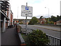
8
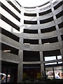
High Wycombe : Dovecot Car Park
A car park beside the Sainsbury store.
Image: © Lewis Clarke
Taken: 9 Oct 2016
0.04 miles
9
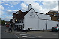
The Bell
Grade II listed. https://www.britishlistedbuildings.co.uk/101332373-the-bell-inn-wycombe
Image: © N Chadwick
Taken: 8 Jul 2017
0.04 miles
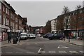
10
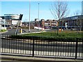
High Wycombe town centre
Junction between Abbey Way, Oxford Road, Arch Way and Oxford Street in High Wycombe town centre (A40).
Image: © Rob Emms
Taken: 26 Feb 2012
0.05 miles