IMAGES TAKEN NEAR TO
Knights Templar Way, HIGH WYCOMBE, HP11 1PX
Introduction
This page details the photographs taken nearby to Knights Templar Way, HP11 1PX by members of the Geograph project.
The Geograph project started in 2005 with the aim of publishing, organising and preserving representative images for every square kilometre of Great Britain, Ireland and the Isle of Man.

There are currently over 7.5m images from over14,400 individuals and you can help contribute to the project by visiting https://www.geograph.org.uk
Image Map (Loading...)


Getting Data...Please wait
Leaflet Map data © OpenStreetMap
Images are licensed for reuse under creativecommons.org/licenses/by-sa/2.0
Notes
- Clicking on the map will re-center to the selected point.
- The higher the marker number, the further away the image location is from the centre of the postcode.
Image Listing (8 Images Found)
Images are licensed for reuse under creativecommons.org/licenses/by-sa/2.0
Image
Details
Distance
1
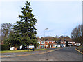
Wallingford Gardens, High Wycombe
A road named after my home town. Got to be worth a picture.
This is one of the last streets on the eastern edge of town for the moment, although a whole lot more houses are going up just a short way away so that could change.
Image: © Des Blenkinsopp
Taken: 20 Feb 2017
0.07 miles
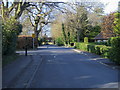
2
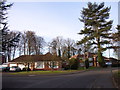
Knights Templar Way
A rather well-to-do and leafy estate on the southern edge of High Wycombe.
Image: © Andrew Smith
Taken: 4 Apr 2006
0.11 miles
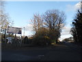
3
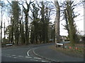
Knights Templar Way at the junction of Daws Hill Lane
Image: © David Howard
Taken: 8 Mar 2015
0.15 miles
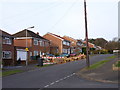
4
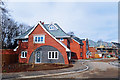
New Houses, Doolittle Avenue
This is a brownfield site shown on the map as a built up area already, but whatever was here has been cleared and a large development of new houses and streets is under construction.
Not your usual boxes either, some interesting designs are being used.
Image: © Des Blenkinsopp
Taken: 20 Feb 2017
0.16 miles
5
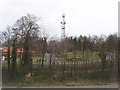
Radio mast at Daws Hill
There are a number of radio masts just by the M40 as it runs over the top of the Chilterns. View from daws Hill Lane bridge over the M40.
Image: © David Hawgood
Taken: 6 Mar 2008
0.19 miles
6
Daws Lea
These houses back onto the M40.
Image: © Andrew Smith
Taken: 4 Apr 2006
0.21 miles
7
St Augustines school lane
St Augustines school lane off Daws Hill Lane
Image: © Shaun Ferguson
Taken: 7 Mar 2008
0.22 miles
8
Entrance to new housing development on Daws Hill Lane
By the bridge over the M40
Image: © David Howard
Taken: 8 Mar 2015
0.25 miles