IMAGES TAKEN NEAR TO
Holly Place, HIGH WYCOMBE, HP11 1LS
Introduction
This page details the photographs taken nearby to Holly Place, HP11 1LS by members of the Geograph project.
The Geograph project started in 2005 with the aim of publishing, organising and preserving representative images for every square kilometre of Great Britain, Ireland and the Isle of Man.

There are currently over 7.5m images from over14,400 individuals and you can help contribute to the project by visiting https://www.geograph.org.uk
Image Map
Images are licensed for reuse under creativecommons.org/licenses/by-sa/2.0
Notes
- Clicking on the map will re-center to the selected point.
- The higher the marker number, the further away the image location is from the centre of the postcode.
Image Listing (7 Images Found)
Images are licensed for reuse under creativecommons.org/licenses/by-sa/2.0
Image
Details
Distance
1
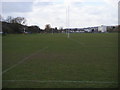
Rugby pitches on King's Mead
Rugby pitches on King's Mead Wycombe Marsh
Image: © Shaun Ferguson
Taken: 7 Mar 2008
0.11 miles
3
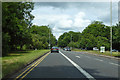
A40 London Road, High Wycombe
The bus lane is only for weekday peak periods.
Image: © Robin Webster
Taken: 9 Jun 2019
0.22 miles
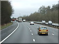
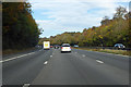
4
Heavy traffic on the M40 west-bound
This was due to stretches of the M4 being closed and traffic diverted to the M40
Image: © Rob Purvis
Taken: 14 Aug 2021
0.23 miles
5
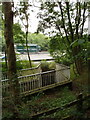
Subway under M40, Flackwell Heath
The Chiltern Way trail goes through this subway in Fennels Wood. From the relative tranquillity of a beech wood one encounters the rushing traffic of the motorway, dives down through a long narrow tunnel, coming out in the woods above High Wycombe and Loudwater.
Image: © David Hawgood
Taken: 29 Aug 2008
0.24 miles
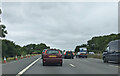
7
M40 towards Oxford
Climbing out of the valley of the River Wye.
Image: © Robin Webster
Taken: 20 Oct 2018
0.25 miles