IMAGES TAKEN NEAR TO
The Sidings, HIGH WYCOMBE, HP11 1GE
Introduction
This page details the photographs taken nearby to The Sidings, HP11 1GE by members of the Geograph project.
The Geograph project started in 2005 with the aim of publishing, organising and preserving representative images for every square kilometre of Great Britain, Ireland and the Isle of Man.

There are currently over 7.5m images from over14,400 individuals and you can help contribute to the project by visiting https://www.geograph.org.uk
Image Map
Images are licensed for reuse under creativecommons.org/licenses/by-sa/2.0
Notes
- Clicking on the map will re-center to the selected point.
- The higher the marker number, the further away the image location is from the centre of the postcode.
Image Listing (12 Images Found)
Images are licensed for reuse under creativecommons.org/licenses/by-sa/2.0
Image
Details
Distance
1
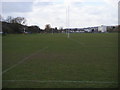
Rugby pitches on King's Mead
Rugby pitches on King's Mead Wycombe Marsh
Image: © Shaun Ferguson
Taken: 7 Mar 2008
0.16 miles
2
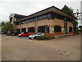
New Practical Driving Test Centre, Kingsmead Business Park
Situated in Regus, Aston Court, Frederick Place HP11 1JU, this driving test centre opened on Monday 26th June 2023 replacing the previous DTC in Cliveden Office Village which closed on Friday 29th April 2022, https://www.geograph.org.uk/photo/6878389 refers. It carries out practical tests on cars only. Hopefully, this new DTC will see a longer tenure than the previous DTC which saw nearly only one year's use until it closed.
Image: © David Hillas
Taken: 1 Sep 2023
0.18 miles
3
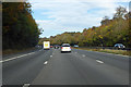
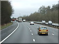
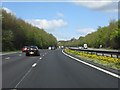
M40 towards Oxford
Climbing out of the valley of the River Wye.
Image: © Robin Webster
Taken: 20 Oct 2018
0.19 miles
4
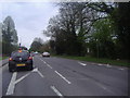
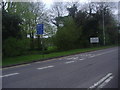
London Road at junction of Rayners Avenue
Image: © David Howard
Taken: 13 Apr 2011
0.20 miles
7
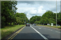
A40 London Road, High Wycombe
The bus lane is only for weekday peak periods.
Image: © Robin Webster
Taken: 9 Jun 2019
0.21 miles
9
M40 motorway climbing north out of the Wye Valley
Part of the second section of the M40, opened in 1969.
Image: © Peter Whatley
Taken: 12 Apr 2011
0.23 miles
10
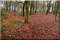
Fennell's Wood
This forms a strip of green land between the houses of Flackwell Heath and the motorway. It is a popular walk, particularly with the village dog walkers, despite the traffic noise. I expect that in the summer the foliage will deaden the sound.
Image: © Graham Horn
Taken: 31 Dec 2010
0.23 miles