IMAGES TAKEN NEAR TO
London Road, HIGH WYCOMBE, HP10 9RF
Introduction
This page details the photographs taken nearby to London Road, HP10 9RF by members of the Geograph project.
The Geograph project started in 2005 with the aim of publishing, organising and preserving representative images for every square kilometre of Great Britain, Ireland and the Isle of Man.

There are currently over 7.5m images from over14,400 individuals and you can help contribute to the project by visiting https://www.geograph.org.uk
Image Map
Images are licensed for reuse under creativecommons.org/licenses/by-sa/2.0
Notes
- Clicking on the map will re-center to the selected point.
- The higher the marker number, the further away the image location is from the centre of the postcode.
Image Listing (34 Images Found)
Images are licensed for reuse under creativecommons.org/licenses/by-sa/2.0
Image
Details
Distance
1
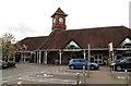
New Tesco Store
Clearing of the old Hancocks yard site in preparation for the new Tesco's store
Image: © Colin Blundell
Taken: Unknown
0.03 miles
4
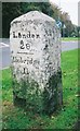
Old Milestone by the A40 in Loudwater
Carved stone post by the A40, in parish of Chepping Wycombe (Wycombe District), London Road; Loudwater, South West exit of traffic island by Tesco's, on wide grass verge beside path, on South side of road. Beaconsfield diamond pillar, erected by the Beaconsfield & Stokenchurch turnpike trust in the 18th century.
Inscription reads:-
: XXVIII / Miles to / London / 1744 : : Oxford / 28 / - / Wycombe / 3 : : London / 28 / - / Uxbridge / 11 :
Grade II listed.
List Entry Number: 1125631 https://historicengland.org.uk/listing/the-list/list-entry/1125631
Milestone Society National ID: BU_LW26
Image: © A Rosevear & J Higgins
Taken: 25 Oct 2001
0.09 miles
5
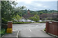
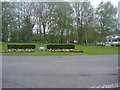
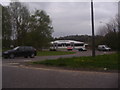
Tescos at Loudwater
From a side road into a private residential estate, and looking across the A40, we can see the top of the Tescos superstore and part of its surrounding car park.
Image: © Graham Horn
Taken: 29 Aug 2011
0.10 miles
6
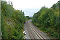
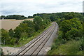
Chiltern line towards Birmingham
There are many cuttings, tunnels and embankments on this line cutting through the Chiltern hills and heading, in this direction, towards Birmingham.
Image: © Graham Horn
Taken: 29 Aug 2011
0.10 miles
7
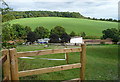
Stables at Loudwater
These buildings are not shown on the 1:25,000 map, but they are definitely here. Beyond is the grassland of Wooburn Moor.
Image: © Graham Horn
Taken: 29 Aug 2011
0.11 miles
10
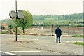
Chiltern line towards London
The flat crossing for the footpath has now been replaced by an overbridge, on which I am standing. The tunnel is in the next square east Image A train heading in this direction would be going to London Marylebone.
Image: © Graham Horn
Taken: 29 Aug 2011
0.14 miles