IMAGES TAKEN NEAR TO
Valeside Avenue, HP10 9FY
Introduction
This page details the photographs taken nearby to Valeside Avenue, HP10 9FY by members of the Geograph project.
The Geograph project started in 2005 with the aim of publishing, organising and preserving representative images for every square kilometre of Great Britain, Ireland and the Isle of Man.

There are currently over 7.5m images from over14,400 individuals and you can help contribute to the project by visiting https://www.geograph.org.uk
Image Map
Images are licensed for reuse under creativecommons.org/licenses/by-sa/2.0
Notes
- Clicking on the map will re-center to the selected point.
- The higher the marker number, the further away the image location is from the centre of the postcode.
Image Listing (16 Images Found)
Images are licensed for reuse under creativecommons.org/licenses/by-sa/2.0
Image
Details
Distance
1
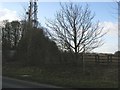
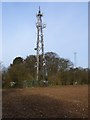
Footpath to Keep Hill
Footpath to Keep Hill by aerial mast on Abbey Barn Lane
Image: © Shaun Ferguson
Taken: 7 Mar 2008
0.10 miles
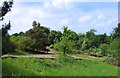
3
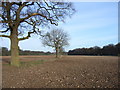
Farmland above Wycombe
Viewed from near Abbey Barn Farm, looking across to Deangarden Wood (right of picture).
Image: © Andrew Smith
Taken: 4 Apr 2006
0.15 miles
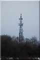
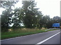
5
Telecommunications masts above Wycombe
Next to the road near Abbey Barn Farm.
Image: © Andrew Smith
Taken: 4 Apr 2006
0.17 miles
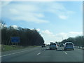
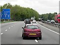
7
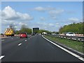
M40 motorway at High Wycombe services site
The maintenance vehicle marks what was intended to be the northbound access from a proposed service area. Abbey Barn Lane - the bridge parapets for which are just visible - would have provided access for deliveries.
Image: © Peter Whatley
Taken: 12 Apr 2011
0.18 miles
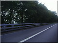
10
Where the Ski Centre was
The Wycombe Summit dry ski slope had a chequered decade of life between 1994 and 2005. We had some good evenings here back in the day, but the venture was continually beset by problems, including a fatality and subsequent court case. The final straw was a fire in 2005 which destroyed the lodge building at the summit.
Various rumours have gone around about a new venture, but finally in 2016 the site was marked out for housing with leisure access to the surrounding woodland. https://en.wikipedia.org/wiki/Wycombe_Summit
I'm surprised the map still marks it.
Image: © Des Blenkinsopp
Taken: 31 May 2018
0.20 miles