IMAGES TAKEN NEAR TO
Chiltern Green, HIGH WYCOMBE, HP10 9AJ
Introduction
This page details the photographs taken nearby to Chiltern Green, HP10 9AJ by members of the Geograph project.
The Geograph project started in 2005 with the aim of publishing, organising and preserving representative images for every square kilometre of Great Britain, Ireland and the Isle of Man.

There are currently over 7.5m images from over14,400 individuals and you can help contribute to the project by visiting https://www.geograph.org.uk
Image Map
Images are licensed for reuse under creativecommons.org/licenses/by-sa/2.0
Notes
- Clicking on the map will re-center to the selected point.
- The higher the marker number, the further away the image location is from the centre of the postcode.
Image Listing (7 Images Found)
Images are licensed for reuse under creativecommons.org/licenses/by-sa/2.0
Image
Details
Distance
1
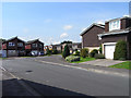
Highfield Road, Flackwell Heath
Highfield Road comprises a short thoroughfare connecting Sedgmoor Road and Carrington Avenue along with two cul-de-sacs going off to the left.
Image: © Andrew Smith
Taken: 8 Aug 2009
0.07 miles
2
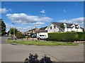
Flackwell Heath
Corner of Chapel Road and Highlea Avenue.
Image: © James Emmans
Taken: 28 Jul 2020
0.13 miles
4
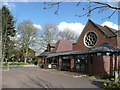
Christ Church, Flackwell Heath
Christ Church, the Parish Church of Flackwell Heath, was built in 1932 and extended in 1959, to serve the growing "village" which now has a population of 9000.
The new extension, seen to the left, was completed in 2001.
Image: © Jonathan Billinger
Taken: 7 Apr 2008
0.16 miles
6
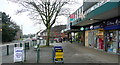
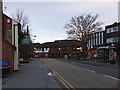
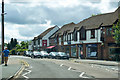
Flackwell Heath shops
The parade of shops in this expanding village. There are most things you need, a small supermarket, a chemist, a newsagent, a couple of Indian restaurants, a couple of cash machines.
Image: © Graham Horn
Taken: 31 Dec 2010
0.22 miles
7

Footpath towards Sheepridge Lane
Open countryside close to Flackwell Heath.
Image: © James Emmans
Taken: 28 Jul 2020
0.25 miles