IMAGES TAKEN NEAR TO
Woodside Way, HIGH WYCOMBE, HP10 8DZ
Introduction
This page details the photographs taken nearby to Woodside Way, HP10 8DZ by members of the Geograph project.
The Geograph project started in 2005 with the aim of publishing, organising and preserving representative images for every square kilometre of Great Britain, Ireland and the Isle of Man.

There are currently over 7.5m images from over14,400 individuals and you can help contribute to the project by visiting https://www.geograph.org.uk
Image Map
Images are licensed for reuse under creativecommons.org/licenses/by-sa/2.0
Notes
- Clicking on the map will re-center to the selected point.
- The higher the marker number, the further away the image location is from the centre of the postcode.
Image Listing (53 Images Found)
Images are licensed for reuse under creativecommons.org/licenses/by-sa/2.0
Image
Details
Distance
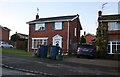
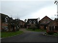
2
Ashley Drive, Tyler's Green
Modern houses occupy most of the western half of the grid-square.
Image: © Andrew Smith
Taken: 8 Apr 2006
0.08 miles
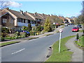
6
Navigating northwards up the Bashire (59)
Nursery Close
Image: © Basher Eyre
Taken: 29 Oct 2024
0.17 miles
7
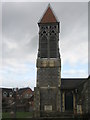
A fine church tower
St Margaret's, Tylers Green.
Image: © Mr Ignavy
Taken: 22 Feb 2009
0.18 miles
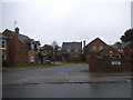
8
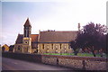
St Margaret's Church, Tylers Green
St Margaret's viewed from the other side of Church Road
Image: © Ian Brackenridge
Taken: Unknown
0.18 miles
9
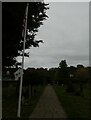
St Margaret, Tylers Green: churchyard (x)
Image: © Basher Eyre
Taken: 29 Oct 2024
0.18 miles
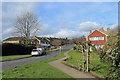
10
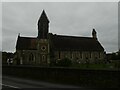
St Margaret, Tylers Green: autumn 2024
Image: © Basher Eyre
Taken: 29 Oct 2024
0.18 miles