IMAGES TAKEN NEAR TO
Green Common Lane, HIGH WYCOMBE, HP10 0LJ
Introduction
This page details the photographs taken nearby to Green Common Lane, HP10 0LJ by members of the Geograph project.
The Geograph project started in 2005 with the aim of publishing, organising and preserving representative images for every square kilometre of Great Britain, Ireland and the Isle of Man.

There are currently over 7.5m images from over14,400 individuals and you can help contribute to the project by visiting https://www.geograph.org.uk
Image Map (Loading...)


Getting Data...Please wait
Leaflet Map data © OpenStreetMap
Images are licensed for reuse under creativecommons.org/licenses/by-sa/2.0
Notes
- Clicking on the map will re-center to the selected point.
- The higher the marker number, the further away the image location is from the centre of the postcode.
Image Listing (14 Images Found)
Images are licensed for reuse under creativecommons.org/licenses/by-sa/2.0
Image
Details
Distance
1
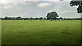
Field south of Green Common Lane
View towards Odds Farm.
Image: © James Emmans
Taken: 1 Jul 2021
0.07 miles
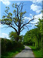
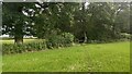
3
Bend in Green Common Lane
Towards Castleman's Farm.
Image: © JThomas
Taken: 26 May 2022
0.10 miles
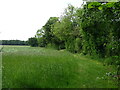
6
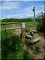
Footpath through field from Green Common Lane
Image: © Shazz
Taken: 13 May 2013
0.12 miles
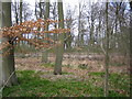
8
Dipple Wood in Autumn
A shot from the public footpath on the edge of Dipple Wood, part of the Hall Barn Estate
Image: © Rob Rogers
Taken: 7 Nov 2010
0.17 miles
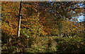
10
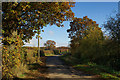
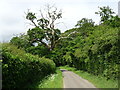
Green Common Lane, Wooburn Common
Running between Castleman's Farm and Odds Farm
Image: © Rob Rogers
Taken: 7 Nov 2010
0.17 miles