IMAGES TAKEN NEAR TO
Minskip Lane, KNARESBOROUGH, HG5 9LN
Introduction
This page details the photographs taken nearby to Minskip Lane, HG5 9LN by members of the Geograph project.
The Geograph project started in 2005 with the aim of publishing, organising and preserving representative images for every square kilometre of Great Britain, Ireland and the Isle of Man.

There are currently over 7.5m images from over14,400 individuals and you can help contribute to the project by visiting https://www.geograph.org.uk
Image Map
Images are licensed for reuse under creativecommons.org/licenses/by-sa/2.0
Notes
- Clicking on the map will re-center to the selected point.
- The higher the marker number, the further away the image location is from the centre of the postcode.
Image Listing (20 Images Found)
Images are licensed for reuse under creativecommons.org/licenses/by-sa/2.0
Image
Details
Distance
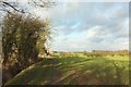
1

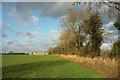
Carr Top Farm
The name is a reference to Staveley Carrs, the former name of Staveley Nature Reserve. View along footpath 15 113/8/1.
Image: © Derek Harper
Taken: 22 Dec 2016
0.03 miles
2
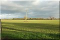
Field north of Carr Top Farm
Looking right from where Image] was taken.
Image: © Derek Harper
Taken: 22 Dec 2016
0.03 miles
3
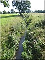
River Tutt at Carr Top Farm
The term "river" seems a bit over the top for such a small watercourse; also known as Fleet Beck, it flows into the River Ure just upstream from Boroughbridge.
Image: © Oliver Dixon
Taken: 23 Aug 2019
0.04 miles
4
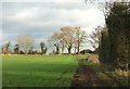
Path approaching Carr Top Farm
Image was taken a few metres ahead; in this view most of the farm buildings are still hidden.
Image: © Derek Harper
Taken: 22 Dec 2016
0.05 miles
5
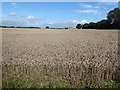
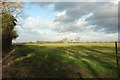
Wheatfield near Carr Top Farm
Under big skies. Newlands Farm Image can be seen on the far side of this huge field.
Image: © Oliver Dixon
Taken: 23 Aug 2019
0.06 miles
6
Towards Newfields Farm
From the stretch of footpath shown in Image
Image: © Derek Harper
Taken: 22 Dec 2016
0.09 miles
7
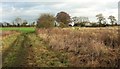
Approaching Carr Top Farm
Footpath 15 113/8/1 runs beside the River Tutt, hidden by vegetation on the right, towards the farm, right of centre behind trees. Across the river is Upper Marsh, part of Staveley Nature Reserve.
Image: © Derek Harper
Taken: 22 Dec 2016
0.10 miles
8
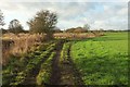
Path by the Tutt
A reverse view of Image], with the river on the left of footpath 15 113/8/1. The more distnt bushes and trees, right of centre about 230 metres away, are on the set aside area by the drainage channel mentioned at Image
Image: © Derek Harper
Taken: 22 Dec 2016
0.12 miles
9
Field north of Carr Top Farm
From footpath 15 113/8/4 as it runs along the edge of the field towards Newfields Farm.
Image: © Derek Harper
Taken: 22 Dec 2016
0.13 miles
10
Approaching Newfields Farm
Footpath 15 113/8/4 reaches the end of the field shown in Image Image was taken a short distance ahead, looking left. In the distance is the house at Moorhouses.
Image: © Derek Harper
Taken: 22 Dec 2016
0.14 miles