IMAGES TAKEN NEAR TO
Main Street, KNARESBOROUGH, HG5 9HY
Introduction
This page details the photographs taken nearby to Main Street, HG5 9HY by members of the Geograph project.
The Geograph project started in 2005 with the aim of publishing, organising and preserving representative images for every square kilometre of Great Britain, Ireland and the Isle of Man.

There are currently over 7.5m images from over14,400 individuals and you can help contribute to the project by visiting https://www.geograph.org.uk
Image Map
Images are licensed for reuse under creativecommons.org/licenses/by-sa/2.0
Notes
- Clicking on the map will re-center to the selected point.
- The higher the marker number, the further away the image location is from the centre of the postcode.
Image Listing (56 Images Found)
Images are licensed for reuse under creativecommons.org/licenses/by-sa/2.0
Image
Details
Distance
1
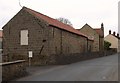
Tied Barn in Scotton
Re-roofed sandstone barn on Main Street in Scotton.
Image: © Matthew Hatton
Taken: 27 Mar 2011
0.03 miles
3
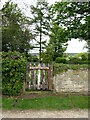
Entrance to Quaker burial ground
Simple burial ground tucked away in a quiet corner of Scotton village.
Image: © Gordon Hatton
Taken: 17 May 2021
0.05 miles
4
![Quaker [Friends] burial ground, Scotton](https://s2.geograph.org.uk/geophotos/06/84/27/6842758_31bbe853_120x120.jpg)
Quaker [Friends] burial ground, Scotton
I'm no expert regarding the Quaker traditions, but several of the burial grounds I have come across have been out in the countryside and either have very few memorial stones or none at all. Many also appear to have become abandoned in the early Victorian period, which makes this one unusual in that it has a number of gravestones, most of which appear to be dated from the 19th or 20th century. Added information November 2021. I am reliably informed that the rows of gravestones seen in this photo are those belonging to local Methodists, some of which were buried here. Apparently the Quaker graves are further to the right.
Image: © Gordon Hatton
Taken: 17 May 2021
0.05 miles

6
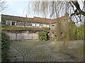
The Old Manor House, Scotton
Newer extensions dating from the 19th & 20th centuries have enclosed a well-preserved 16th century timber-framed and stone manor house, which was given a Grade II listing in 1952 http://www.britishlistedbuildings.co.uk/en-331810-the-old-manor-house-scotton-north-yorksh The original building may well have survived largely intact because of its associations with the local Percy and Fawkes families, Guy Fawkes of the latter being of 'Gunpowder Plot' fame.
Image: © Richard Law
Taken: 21 Feb 2017
0.07 miles
7
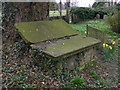
Tombs on a Tilt
18thC Chest Tombs of the Watkinson family made of local sandstone in Scotton Quaker Burial Ground.
Image: © Matthew Hatton
Taken: 27 Mar 2011
0.07 miles
8
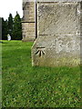
OS benchmark - Scotton, St Thomas' church
An OS cutmark on the wall of the church; originally levelled at 207' 10" above Ordnance Datum Newlyn, and shown on the 1907 maps - which suggests it actually dates from the 1st primary levellings of England & Wales in the 1850s.
Image: © Richard Law
Taken: 21 Feb 2017
0.07 miles
9
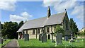
Scotton, St Thomas's church
There is a benchmark cut into the rear of the church, on the north east face.
Image: © Mel Towler
Taken: 8 May 2022
0.07 miles
10
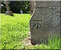
Scotton, St Thomas's church
The benchmark is cut into the rear of the church, on the north east face.
Image: © Mel Towler
Taken: 8 May 2022
0.07 miles