IMAGES TAKEN NEAR TO
Woodpark Avenue, KNARESBOROUGH, HG5 9DJ
Introduction
This page details the photographs taken nearby to Woodpark Avenue, HG5 9DJ by members of the Geograph project.
The Geograph project started in 2005 with the aim of publishing, organising and preserving representative images for every square kilometre of Great Britain, Ireland and the Isle of Man.

There are currently over 7.5m images from over14,400 individuals and you can help contribute to the project by visiting https://www.geograph.org.uk
Image Map
Images are licensed for reuse under creativecommons.org/licenses/by-sa/2.0
Notes
- Clicking on the map will re-center to the selected point.
- The higher the marker number, the further away the image location is from the centre of the postcode.
Image Listing (101 Images Found)
Images are licensed for reuse under creativecommons.org/licenses/by-sa/2.0
Image
Details
Distance
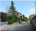
1

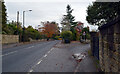
Woodpark Avenue and Woodpark Drive
Woodpark Avenue is straight ahead with Woodpark Drive on the left.
Image: © DS Pugh
Taken: 29 Dec 2024
0.02 miles
2
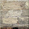
Knaresborough, Scotch George Lane
The benchmark is cut into the roadside wall on the north side of the lane and opposite house number 9.
Image: © Mel Towler
Taken: 13 Sep 2022
0.08 miles
3
Knaresborough, Scotch George Lane
There is a benchmark cut into the roadside wall on the north side of the lane, and opposite house number 9.
Image: © Mel Towler
Taken: 13 Sep 2022
0.08 miles
4
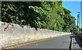
Wall along Scotch George Lane
Over the wall is Jacob Smith Park.
Image: © DS Pugh
Taken: 29 Dec 2024
0.09 miles
5
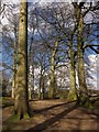
Trees in James Smith Park
A path along the hillside on the southern edge of the park.
Image: © Derek Harper
Taken: 5 Apr 2013
0.09 miles
6
Junction of Boroughbridge Road (A6055) and Blind Lane, Knaresborough
Image: © habiloid
Taken: 28 Oct 2020
0.10 miles
7
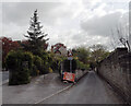
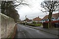
Blind Lane, Knaresborough
View from Blind Lane's junction with Boroughbridge Road (A6055).
Image: © habiloid
Taken: 13 May 2012
0.10 miles
8
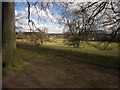
Jacob Smith Park, Scriven
From a path along the southern edge of the park through Guiseley Hill Plantation. The tree, or pair of trees, right of centre, is just over a gridline in Image
Image: © Derek Harper
Taken: 5 Apr 2013
0.10 miles
9
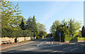
Scriven Road
Scriven Road at its junction with Boroughbridge Road.
Image: © habiloid
Taken: 14 May 2019
0.11 miles
10
Blind Lane
Boroughbridge Road is on the left of the picture.
Image: © habiloid
Taken: 13 May 2019
0.11 miles