IMAGES TAKEN NEAR TO
Nidd Bank, KNARESBOROUGH, HG5 9BX
Introduction
This page details the photographs taken nearby to Nidd Bank, HG5 9BX by members of the Geograph project.
The Geograph project started in 2005 with the aim of publishing, organising and preserving representative images for every square kilometre of Great Britain, Ireland and the Isle of Man.

There are currently over 7.5m images from over14,400 individuals and you can help contribute to the project by visiting https://www.geograph.org.uk
Image Map
Images are licensed for reuse under creativecommons.org/licenses/by-sa/2.0
Notes
- Clicking on the map will re-center to the selected point.
- The higher the marker number, the further away the image location is from the centre of the postcode.
Image Listing (58 Images Found)
Images are licensed for reuse under creativecommons.org/licenses/by-sa/2.0
Image
Details
Distance
1
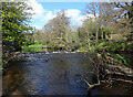
Weir on the River Nidd seen from the Horseshoe Field, Knaresborough
Image: © habiloid
Taken: 18 Apr 2014
0.06 miles
4
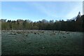
Mist on the Nidd
Looking upstream along the river with a mist on the water.
Image: © DS Pugh
Taken: 22 Dec 2020
0.11 miles
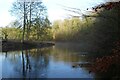
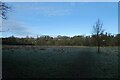
5
Fields on the banks of the Nidd
Looking across a field near Conyngham Hall.
Image: © DS Pugh
Taken: 22 Dec 2020
0.12 miles
6
Fields near Conyngham Hall
Looking across a field on the banks of the River Nidd.
Image: © DS Pugh
Taken: 22 Dec 2020
0.12 miles

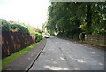
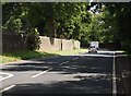
9
Road Sign, Ripley Road - High Bond End
Image: © Mark Anderson
Taken: 17 Apr 2010
0.13 miles
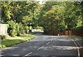
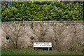
10
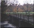
Bridge at Conyngham Park
View northwards across the bridge over the Nidd.
Image: © Trevor Rickard
Taken: Unknown
0.13 miles