IMAGES TAKEN NEAR TO
Ribston Road, KNARESBOROUGH, HG5 8ND
Introduction
This page details the photographs taken nearby to Ribston Road, HG5 8ND by members of the Geograph project.
The Geograph project started in 2005 with the aim of publishing, organising and preserving representative images for every square kilometre of Great Britain, Ireland and the Isle of Man.

There are currently over 7.5m images from over14,400 individuals and you can help contribute to the project by visiting https://www.geograph.org.uk
Image Map
Images are licensed for reuse under creativecommons.org/licenses/by-sa/2.0
Notes
- Clicking on the map will re-center to the selected point.
- The higher the marker number, the further away the image location is from the centre of the postcode.
Image Listing (10 Images Found)
Images are licensed for reuse under creativecommons.org/licenses/by-sa/2.0
Image
Details
Distance
1
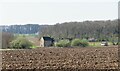
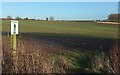
Arable land at Throstle Nest Farm
Looking south west towards the farmhouse with Braham Wood beyond.
Image: © Gordon Hatton
Taken: 4 Apr 2021
0.01 miles
2
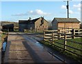
Throstle Nest Farm
Passed by footpath 15 122/5/1, although as with Image] the mapped line of the path is well off to the right. In this case there's clearly been some sort of diversion, as waymarks appear on the route around the farm on the left. Here the metalled road ends, and the path to Little Ribston becomes - well, more path-like.
Image: © Derek Harper
Taken: 23 Dec 2015
0.02 miles
3
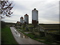
Throstle Nest Farm
Now used as game bird breeding area for the shoots of Plompton Farms.
Image: © manonabike
Taken: 22 Nov 2006
0.05 miles
4
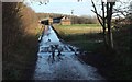
Approaching Throstle Nest Farm
As mentioned at Image], footpath 15 122/5/1 seems to have been realigned along this track. Several outbuildings have been cleared from the field on the right.
Image: © Derek Harper
Taken: 23 Dec 2015
0.05 miles
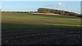
5
Farmland, Throstle Nest Farm
The notice relates to footpath 15 122/5/1, which turns away to the right here around this field. On the right is a corner of Throstlenest Wood.
Image: © Derek Harper
Taken: 23 Dec 2015
0.13 miles
6
Towards Throstlenest Wood
Looking more to the right from the same point as Image], with considerable overlap.
Image: © Derek Harper
Taken: 23 Dec 2015
0.13 miles
7
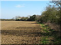
Fieldside path near Braham Wood
Heading east along path 15.109/2 towards Little Ribston. The parish boundary follows the hedgeline on the right.
Image: © Gordon Hatton
Taken: 4 Apr 2021
0.16 miles
8
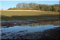
Throstlenest Wood
With a large foreground puddle by footpath 15 122/5/1. See also Image], taken from further northwest.
Image: © Derek Harper
Taken: 23 Dec 2015
0.21 miles
9
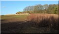
Throstlenest Wood
From footpath 15 122/5/1. A considerable corner swathe of the field, on the right here, has been left fallow.
Image: © Derek Harper
Taken: 23 Dec 2015
0.21 miles
10
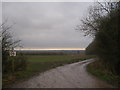
Footpath junction at Braham Wood
Both paths lead to Little Ribston
Image: © John Slater
Taken: 4 Jan 2013
0.21 miles