IMAGES TAKEN NEAR TO
Fountains Way, KNARESBOROUGH, HG5 8HU
Introduction
This page details the photographs taken nearby to Fountains Way, HG5 8HU by members of the Geograph project.
The Geograph project started in 2005 with the aim of publishing, organising and preserving representative images for every square kilometre of Great Britain, Ireland and the Isle of Man.

There are currently over 7.5m images from over14,400 individuals and you can help contribute to the project by visiting https://www.geograph.org.uk
Image Map
Images are licensed for reuse under creativecommons.org/licenses/by-sa/2.0
Notes
- Clicking on the map will re-center to the selected point.
- The higher the marker number, the further away the image location is from the centre of the postcode.
Image Listing (47 Images Found)
Images are licensed for reuse under creativecommons.org/licenses/by-sa/2.0
Image
Details
Distance
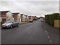
1
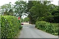
Abbey Road meets Wetherby Road
Looking onto Wetherby Road in Knaresborough.
Image: © DS Pugh
Taken: 4 Jun 2023
0.07 miles
2
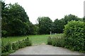
Above the river
Looking towards the River Nidd from Abbey Road.
Image: © DS Pugh
Taken: 4 Jun 2023
0.08 miles
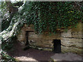
4
St Robert's Cave
St Robert was a hermit who lived here from about 1180 until his death in 1218. Among those who visited him was King John, and after his death the cave became a popular place of pilgrimage.
Image: © Anne Burgess
Taken: 26 May 2016
0.09 miles
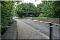
5

The River Nidd
Looking downstream along the River Nidd from the bridge carrying Whetherby Road over the river.
Image: © Graham Robson
Taken: 18 Jul 2020
0.09 miles
6
Farfield Avenue - viewed from Aspin Drive
Image: © Betty Longbottom
Taken: 30 Jan 2017
0.10 miles
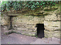
7
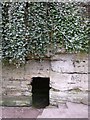
St Robert's Cave
A view of the holy man's cave entrance.
Image: © beamcottage
Taken: 10 Apr 2007
0.10 miles
8
Knaresborough, Grimbald Bridge
There is a rivet benchmark cut into the eastern parapet of the bridge.
Image: © Mel Towler
Taken: 12 Sep 2022
0.10 miles
9
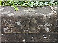
Knaresborough, Grimbald Bridge
The rivet benchmark is cut into the eastern parapet of the bridge.
Image: © Mel Towler
Taken: 12 Sep 2022
0.10 miles
10
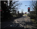
Grimbald Bridge
Traffic lights control the B6164 across this single-lane bridge over the River Nidd. The bridge is listed http://list.historicengland.org.uk/resultsingle.aspx?uid=1315622&searchtype=mapsearch .
Image: © Derek Harper
Taken: 6 Apr 2015
0.10 miles