IMAGES TAKEN NEAR TO
Grange Farm Court, HG5 8FJ
Introduction
This page details the photographs taken nearby to Grange Farm Court, HG5 8FJ by members of the Geograph project.
The Geograph project started in 2005 with the aim of publishing, organising and preserving representative images for every square kilometre of Great Britain, Ireland and the Isle of Man.

There are currently over 7.5m images from over14,400 individuals and you can help contribute to the project by visiting https://www.geograph.org.uk
Image Map
Images are licensed for reuse under creativecommons.org/licenses/by-sa/2.0
Notes
- Clicking on the map will re-center to the selected point.
- The higher the marker number, the further away the image location is from the centre of the postcode.
Image Listing (8 Images Found)
Images are licensed for reuse under creativecommons.org/licenses/by-sa/2.0
Image
Details
Distance
1

Hopperton Pump
Detail on the Hopperton village pump at King Street.
Image: © David Rogers
Taken: 21 Oct 2008
0.16 miles
4
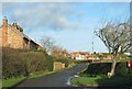
Hopperton Street
Hopperton is a small single street village running south off the A59. These days the road is a dead end as the level crossing on the Harrogate to York railway line has been closed off. A few decades ago it was manned and one could drive onwards to what was the old A1.
Image: © Gordon Hatton
Taken: 27 Dec 2020
0.18 miles
5

Hopperton Village
Viewed from a very short King Street past the village pump and post box towards Hopperton Street.
Image: © David Rogers
Taken: 21 Oct 2008
0.18 miles
6
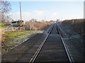
Hopperton level crossing, looking east towards York
Image: © Nigel Thompson
Taken: 26 Dec 2013
0.18 miles