IMAGES TAKEN NEAR TO
Stevenson Place, KNARESBOROUGH, HG5 8DB
Introduction
This page details the photographs taken nearby to Stevenson Place, HG5 8DB by members of the Geograph project.
The Geograph project started in 2005 with the aim of publishing, organising and preserving representative images for every square kilometre of Great Britain, Ireland and the Isle of Man.

There are currently over 7.5m images from over14,400 individuals and you can help contribute to the project by visiting https://www.geograph.org.uk
Image Map
Images are licensed for reuse under creativecommons.org/licenses/by-sa/2.0
Notes
- Clicking on the map will re-center to the selected point.
- The higher the marker number, the further away the image location is from the centre of the postcode.
Image Listing (40 Images Found)
Images are licensed for reuse under creativecommons.org/licenses/by-sa/2.0
Image
Details
Distance
1
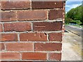
Knaresborough, 3 Stephenson Place
The benchmark is cut into the west facing wall of the house.
Image: © Mel Towler
Taken: 10 May 2022
0.01 miles
2
Knaresborough, 3 Stephenson Place
There is a benchmark cut into the west facing wall of the house. It is on the right corner on the wall alongside the drive.
Image: © Mel Towler
Taken: 10 May 2022
0.01 miles
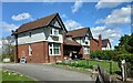
3
Harrogate Road (A59) at Stevenson Place, Knaresborough
Looking north-eastward.
Image: © Peter Wood
Taken: 15 Feb 2023
0.02 miles
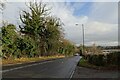
4
Knaresborough, Harrogate Road
According to the OS benchmark database there was bench seat in this location with a benchmark cut into the seat support. Recently a cycle lane has been constructed on the road verge and the bench seat has been removed.
Image: © Mel Towler
Taken: 10 May 2022
0.04 miles
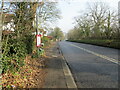
5
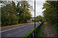
Harrogate Road
The main road between Harrogate and Knaresborough. The road is beginning to descend towards the crossing of the Nidd.
Image: © Bill Boaden
Taken: 26 Oct 2013
0.04 miles
6
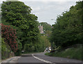
Harrogate Road (A59), Knaresborough
St. John's church can be seen beyond the trees.
Image: © habiloid
Taken: 23 May 2015
0.12 miles
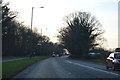
7
Harrogate Road
The A59 between Starbeck and Knaresborough from the end of the cycle lane. A cycle lane runs from here to the top of the hill in Starbeck, but doesn't go from here to Knaresborough. The missing section is only a few hundred yards.
Image: © DS Pugh
Taken: 29 Dec 2024
0.12 miles

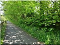
10
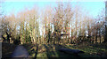
Path and picnic area, Foolish Wood, Knaresborough
Image: © habiloid
Taken: 2 Jan 2023
0.16 miles