IMAGES TAKEN NEAR TO
Moor Lane, KNARESBOROUGH, HG5 0TQ
Introduction
This page details the photographs taken nearby to Moor Lane, HG5 0TQ by members of the Geograph project.
The Geograph project started in 2005 with the aim of publishing, organising and preserving representative images for every square kilometre of Great Britain, Ireland and the Isle of Man.

There are currently over 7.5m images from over14,400 individuals and you can help contribute to the project by visiting https://www.geograph.org.uk
Image Map
Images are licensed for reuse under creativecommons.org/licenses/by-sa/2.0
Notes
- Clicking on the map will re-center to the selected point.
- The higher the marker number, the further away the image location is from the centre of the postcode.
Image Listing (15 Images Found)
Images are licensed for reuse under creativecommons.org/licenses/by-sa/2.0
Image
Details
Distance
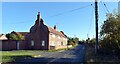
1
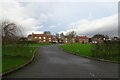
Houses in Low Arkendale
Houses off Moor Lane on the west side of Arkendale.
Image: © DS Pugh
Taken: 29 Dec 2024
0.04 miles
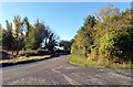
5
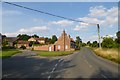
Entering Arkendale
Moor Lane on the outskirts of Arkendale.
Image: © DS Pugh
Taken: 8 Aug 2015
0.08 miles
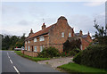
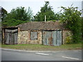
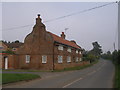
8
On Moor Lane, Lower Arkendale
House with unusual gable ends, perhaps influenced by a Dutch architect.
Image: © Chris Heaton
Taken: 3 Jan 2013
0.09 miles
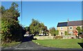
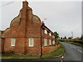
9
House with unusual gable ends
This is on The Reins, Arkendale
Image: © John Slater
Taken: 8 Oct 2012
0.09 miles
10
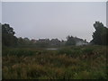
The Mar at Low Arkendale
A pond and area of wetland on the outskirts of Arkendale village
Image: © John Slater
Taken: 8 Oct 2012
0.10 miles