IMAGES TAKEN NEAR TO
Halfpenny Close, KNARESBOROUGH, HG5 0TG
Introduction
This page details the photographs taken nearby to Halfpenny Close, HG5 0TG by members of the Geograph project.
The Geograph project started in 2005 with the aim of publishing, organising and preserving representative images for every square kilometre of Great Britain, Ireland and the Isle of Man.

There are currently over 7.5m images from over14,400 individuals and you can help contribute to the project by visiting https://www.geograph.org.uk
Image Map
Images are licensed for reuse under creativecommons.org/licenses/by-sa/2.0
Notes
- Clicking on the map will re-center to the selected point.
- The higher the marker number, the further away the image location is from the centre of the postcode.
Image Listing (128 Images Found)
Images are licensed for reuse under creativecommons.org/licenses/by-sa/2.0
Image
Details
Distance
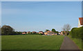
1
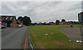
Halfpenny Close and King George's Field, Knaresborough
Image: © habiloid
Taken: 25 Aug 2022
0.02 miles
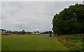
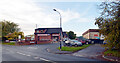
3
Halfpenny Close, Knaresborough
King George V playing fields are on the right.
Image: © habiloid
Taken: 28 Oct 2020
0.02 miles
4
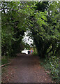
Path from The Cinder Path to Halfpenny Close, Knaresborough
Image: © habiloid
Taken: 25 Aug 2022
0.04 miles
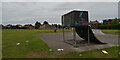
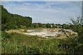
7
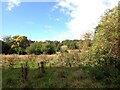
A derelict industrial site, Halfpenny Lane, Knaresborough
Image: © habiloid
Taken: 1 Oct 2022
0.05 miles
8
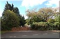
Entrance to a derelict industrial site, Halfpenny Lane, Knaresborough
Image: © habiloid
Taken: 1 Oct 2022
0.05 miles
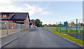
10
Halfpenny Close seen from Halfpenny Lane, Knaresborough
Image: © habiloid
Taken: 28 Oct 2020
0.06 miles