IMAGES TAKEN NEAR TO
Hopperton, KNARESBOROUGH, HG5 0SG
Introduction
This page details the photographs taken nearby to HG5 0SG by members of the Geograph project.
The Geograph project started in 2005 with the aim of publishing, organising and preserving representative images for every square kilometre of Great Britain, Ireland and the Isle of Man.

There are currently over 7.5m images from over14,400 individuals and you can help contribute to the project by visiting https://www.geograph.org.uk
Image Map
Images are licensed for reuse under creativecommons.org/licenses/by-sa/2.0
Notes
- Clicking on the map will re-center to the selected point.
- The higher the marker number, the further away the image location is from the centre of the postcode.
Image Listing (17 Images Found)
Images are licensed for reuse under creativecommons.org/licenses/by-sa/2.0
Image
Details
Distance
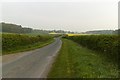
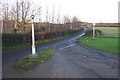
2
Hopperton Street towards A59
The northern end of Hopperton Street as it approaches the junction with the busy A59.
Image: © Gordon Hatton
Taken: 27 Dec 2020
0.09 miles
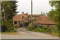
3
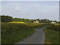
The road to Allerton Castle
The lane leads to Allerton Castle (actually an 18th century mansion, now used as a wedding venue, and not a defensive site), also to St Martin's church (centre) and a caravan park.
Image: © Stephen Craven
Taken: 14 May 2022
0.11 miles
4
Old Lamp Post on Hopperton Street
There used to be two lamp posts here: Image However, only one remains now. The other can be seen damaged in Google Street View images dated 2009 and today there was no sign of it at all.
Image: © Mark Anderson
Taken: 1 May 2019
0.15 miles
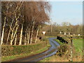
6
Lamp posts by the entrance to The Masons Arms at Hopperton
Looking north towards the junction with the A59
Image: © Jonathan Billinger
Taken: 6 Dec 2006
0.17 miles
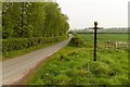
7
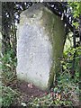
Old Milestone south of Allerton Mauleverer
Carved stone post by the UC road, in parish of Allerton Mauleverer with Hopperton (Harrogate District), in lane from main road, in hedge, on East side of road. Erected by an unknown authority in the 18th/19th century.
Inscription once read:-
: (Green Hammerton / 2½) : : (Knaresborough / 5) :
North Yorkshire HER.
NY SMR Number: MNY37964 https://www.heritagegateway.org.uk/Gateway/Results_Single.aspx?uid=MNY37964&resourceID=1009
Milestone Society National ID: YN_KBGH05
Image: © J Howatt
Taken: 17 Apr 2012
0.19 miles
8
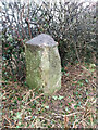
Old milestone
Once the vegetation had been cleared the original shape of this milestone can be seen. The damage to the right hand side was probably caused by a hedge cutter since 2012 when this milestone was first found.
Image: © Hilary Jones
Taken: 29 Jan 2024
0.19 miles
9
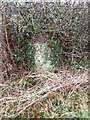
Old milestone
The old milestone on the original line of the route from Knaresborough to Green Hammerton through Allerton Mauleverer photographed before the vegetation was cleared to fully reveal the stone.
Image: © Hilary Jones
Taken: 29 Jan 2024
0.19 miles