IMAGES TAKEN NEAR TO
Boroughbridge Road, KNARESBOROUGH, HG5 0QQ
Introduction
This page details the photographs taken nearby to Boroughbridge Road, HG5 0QQ by members of the Geograph project.
The Geograph project started in 2005 with the aim of publishing, organising and preserving representative images for every square kilometre of Great Britain, Ireland and the Isle of Man.

There are currently over 7.5m images from over14,400 individuals and you can help contribute to the project by visiting https://www.geograph.org.uk
Image Map
Images are licensed for reuse under creativecommons.org/licenses/by-sa/2.0
Notes
- Clicking on the map will re-center to the selected point.
- The higher the marker number, the further away the image location is from the centre of the postcode.
Image Listing (7 Images Found)
Images are licensed for reuse under creativecommons.org/licenses/by-sa/2.0
Image
Details
Distance
1
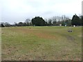
Knaresborough clay pigeon shooting ground
A lot of dead clays here... the ground is littered with orange and black debris.
Image: © Richard Law
Taken: 19 Mar 2013
0.04 miles
2
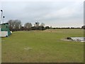
A shooter's view of the clay ground
Looking up the clay-pigeon shoot from the clubhouse. The place was deserted the day I visited, otherwise I'd not have wandered across the range quite so happily.
Image: © Richard Law
Taken: 19 Mar 2013
0.05 miles
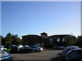
3
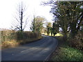
Boroughbridge Road (A6055)
Heading north east.
Image: © JThomas
Taken: 30 Nov 2013
0.06 miles
6
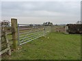
A trig in the corner of a field
Trig point TP3347, with flush bracket 7584, in the corner of a field above Gibbet House Farm.
Image: © Richard Law
Taken: 19 Mar 2013
0.20 miles
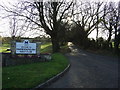
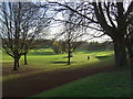
7
Knaresborough Golf Club
A busy and beautiful day at the Golf Club with some sort of competition taking place. I got a few strange looks when I turned up on my bike, obviously not obeying the de rigueur dress code.
Image: © manonabike
Taken: 1 Nov 2006
0.22 miles