IMAGES TAKEN NEAR TO
Boroughbridge Road, KNARESBOROUGH, HG5 0QL
Introduction
This page details the photographs taken nearby to Boroughbridge Road, HG5 0QL by members of the Geograph project.
The Geograph project started in 2005 with the aim of publishing, organising and preserving representative images for every square kilometre of Great Britain, Ireland and the Isle of Man.

There are currently over 7.5m images from over14,400 individuals and you can help contribute to the project by visiting https://www.geograph.org.uk
Image Map
Images are licensed for reuse under creativecommons.org/licenses/by-sa/2.0
Notes
- Clicking on the map will re-center to the selected point.
- The higher the marker number, the further away the image location is from the centre of the postcode.
Image Listing (4 Images Found)
Images are licensed for reuse under creativecommons.org/licenses/by-sa/2.0
Image
Details
Distance
2
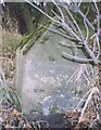
Old Milestone, on the A6055, Spellow Hill
Located on the East side of road, 100m south of Spellow Cottages opp double white lines. Stone post (plate lost), 18th century.
Inscription reads: (Boroughbridge 3, Knaresborough 4, Harrogate 7)
Milestone Society National ID: YN_HGBB07
Image: © Christine Minto
Taken: 21 Dec 2005
0.02 miles
4
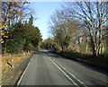
A6055 at Pellow Hill
The A6055 half way between Knaresborough and Boroughbridge. The line of the road was originally surveyed by 'Blind Jack' Metcalfe of Knaresborough. This section should always be driven with care during the hours of darkness as roe deer often leap out of the roadside woodland.
Image: © Gordon Hatton
Taken: 9 Mar 2012
0.20 miles