IMAGES TAKEN NEAR TO
Castle Garden Drive, HG5 0GR
Introduction
This page details the photographs taken nearby to Castle Garden Drive, HG5 0GR by members of the Geograph project.
The Geograph project started in 2005 with the aim of publishing, organising and preserving representative images for every square kilometre of Great Britain, Ireland and the Isle of Man.

There are currently over 7.5m images from over14,400 individuals and you can help contribute to the project by visiting https://www.geograph.org.uk
Image Map
Images are licensed for reuse under creativecommons.org/licenses/by-sa/2.0
Notes
- Clicking on the map will re-center to the selected point.
- The higher the marker number, the further away the image location is from the centre of the postcode.
Image Listing (25 Images Found)
Images are licensed for reuse under creativecommons.org/licenses/by-sa/2.0
Image
Details
Distance
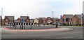
1
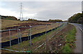
Development site, Boroughbridge Road (A6055), Knaresborough
Image: © habiloid
Taken: 28 Oct 2020
0.07 miles
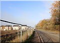
3
A building site seen from Boroughbridge Road (A6055), Knaresborough
Image: © habiloid
Taken: 2 Dec 2022
0.09 miles
4
Entrance to Calmwater Bay, Boroughbridge Road (A6055), Knaresborough
Calmwater Bay is a waterski and water board club based in a disused quarry on the outskirts of Knaresborough.
Image: © habiloid
Taken: 28 Oct 2020
0.12 miles
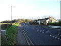
5

"Welcome to Knaresborough" sign, Boroughbridge Road (A6055)
Image: © habiloid
Taken: 28 Oct 2020
0.12 miles

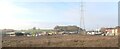
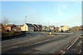
7
Housing development at Knaresborough
Looking across a recently constructed roundabout on the A6055 Boroughbridge Road towards the new housing development that is swallowing up fields on this northern edge of Knaresborough. There must be something odd about the roundabout as two members of my family have already seen motorists driving around the wrong side of it!
Image: © Gordon Hatton
Taken: 14 Jan 2018
0.19 miles
9
The junction of Chestnut Drive and Boroughbridge Road (A6055), Knaresborough
Image: © habiloid
Taken: 2 Dec 2022
0.20 miles
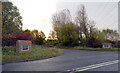
10
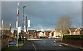
Roundabout, Boroughbridge Road
Seen from Bar Lane Image Boroughbridge Road, right and left, is the A6055. Across the roundabout is recent housing at The Pastures.
Image: © Derek Harper
Taken: 23 Dec 2019
0.20 miles