IMAGES TAKEN NEAR TO
High Street, KNARESBOROUGH, HG5 0EX
Introduction
This page details the photographs taken nearby to High Street, HG5 0EX by members of the Geograph project.
The Geograph project started in 2005 with the aim of publishing, organising and preserving representative images for every square kilometre of Great Britain, Ireland and the Isle of Man.

There are currently over 7.5m images from over14,400 individuals and you can help contribute to the project by visiting https://www.geograph.org.uk
Image Map
Images are licensed for reuse under creativecommons.org/licenses/by-sa/2.0
Notes
- Clicking on the map will re-center to the selected point.
- The higher the marker number, the further away the image location is from the centre of the postcode.
Image Listing (1042 Images Found)
Images are licensed for reuse under creativecommons.org/licenses/by-sa/2.0
Image
Details
Distance
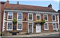
1
114, High St
Grade II listed. http://www.britishlistedbuildings.co.uk/en-330814-112-114-high-street-knaresborough-north-
Image: © N Chadwick
Taken: 26 Aug 2014
0.00 miles
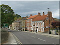
3
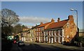
High Street, Knaresborough
Most of the buildings are listed; the nearest are described at http://www.historicengland.org.uk/listing/the-list/list-entry/1315628 .
Image: © Derek Harper
Taken: 23 Dec 2015
0.01 miles
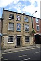
4
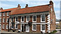
104-106 High Street Knaresborough
A most attractive brick house of circa 1700 at the lower end of Knaresborough High Street. Now occupied by an estate agency.
Image: © Gordon Hatton
Taken: 31 Aug 2007
0.01 miles
5
104 - 6 High St
Grade II listed. http://www.britishlistedbuildings.co.uk/en-330813-104-106-high-street-knaresborough-north-
Image: © N Chadwick
Taken: 26 Aug 2014
0.01 miles
6

104 & 106 High Street
Grade II listed late 17th century houses, now Lister Haigh Estate Agents
Image: © Richard Croft
Taken: 16 Feb 2019
0.01 miles
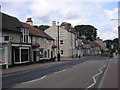
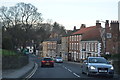
7
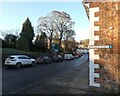
High Street, Knaresborough
Buildings at the northern end of High Street in Knaresborough. High Street forms part of the route of the trunk A59 road.
Image: © Malc McDonald
Taken: 14 Oct 2021
0.01 miles
9
High Street (A59) seen from its junction with Stead's Yard, Knaresborough
Image: © habiloid
Taken: 14 Dec 2022
0.02 miles