IMAGES TAKEN NEAR TO
Berrys Avenue, KNARESBOROUGH, HG5 0EP
Introduction
This page details the photographs taken nearby to Berrys Avenue, HG5 0EP by members of the Geograph project.
The Geograph project started in 2005 with the aim of publishing, organising and preserving representative images for every square kilometre of Great Britain, Ireland and the Isle of Man.

There are currently over 7.5m images from over14,400 individuals and you can help contribute to the project by visiting https://www.geograph.org.uk
Image Map
Images are licensed for reuse under creativecommons.org/licenses/by-sa/2.0
Notes
- Clicking on the map will re-center to the selected point.
- The higher the marker number, the further away the image location is from the centre of the postcode.
Image Listing (1175 Images Found)
Images are licensed for reuse under creativecommons.org/licenses/by-sa/2.0
Image
Details
Distance
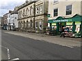
1
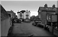
Berry's Avenue seen from Park Crest, Knaresborough
Image: © habiloid
Taken: 25 Dec 2022
0.01 miles
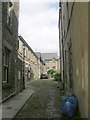
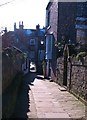
2
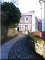
Berry's Passage
The NE end of Berry's Passage which leads towards the High Street from Berry's Avenue. In the background, a rather fine early 19th century house of dressed gritstone.
Image: © Gordon Hatton
Taken: 2 Mar 2010
0.02 miles
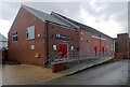
4
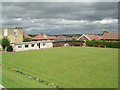
Knaresborough Bowling Club - Park Crest
Image: © Betty Longbottom
Taken: 31 Aug 2009
0.03 miles
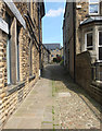
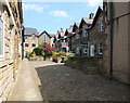
5
Berry's Passage
Berry's Passage is a stone flagged walkway or 'Ginnel' leading off the High Street in Knaresborough.
Image: © Gordon Hatton
Taken: 2 Mar 2010
0.03 miles
6
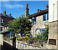
The Old Cottage, Berry's Passage, Knaresborough
Image: © habiloid
Taken: 20 Jun 2010
0.04 miles