IMAGES TAKEN NEAR TO
Marshalls Court, KNARESBOROUGH, HG5 0ED
Introduction
This page details the photographs taken nearby to Marshalls Court, HG5 0ED by members of the Geograph project.
The Geograph project started in 2005 with the aim of publishing, organising and preserving representative images for every square kilometre of Great Britain, Ireland and the Isle of Man.

There are currently over 7.5m images from over14,400 individuals and you can help contribute to the project by visiting https://www.geograph.org.uk
Image Map
Images are licensed for reuse under creativecommons.org/licenses/by-sa/2.0
Notes
- Clicking on the map will re-center to the selected point.
- The higher the marker number, the further away the image location is from the centre of the postcode.
Image Listing (896 Images Found)
Images are licensed for reuse under creativecommons.org/licenses/by-sa/2.0
Image
Details
Distance
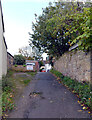
2
Footpath connecting Park Place and Park Row
Image: © habiloid
Taken: 13 May 2019
0.02 miles
6
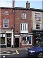
Jade Garden Takeaway - High Street
Image: © Betty Longbottom
Taken: 22 Oct 2010
0.02 miles
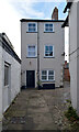
7
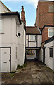
Anchor Yard, Knaresborough
The bus station can be seen across High Street through the archway.
Image: © habiloid
Taken: 28 Oct 2020
0.02 miles
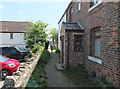
8
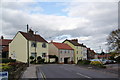
Park Row, Knaresborough
A road giving access to the north eastern suburbs
Image: © Bill Boaden
Taken: 26 Oct 2013
0.03 miles
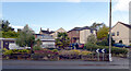
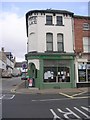
10
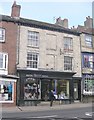
Two of the "Town Windows", High Street (A59), Knaresborough
Image: © habiloid
Taken: 2 May 2009
0.03 miles