IMAGES TAKEN NEAR TO
Charlton Villas, KNARESBOROUGH, HG5 0DF
Introduction
This page details the photographs taken nearby to Charlton Villas, HG5 0DF by members of the Geograph project.
The Geograph project started in 2005 with the aim of publishing, organising and preserving representative images for every square kilometre of Great Britain, Ireland and the Isle of Man.

There are currently over 7.5m images from over14,400 individuals and you can help contribute to the project by visiting https://www.geograph.org.uk
Image Map
Images are licensed for reuse under creativecommons.org/licenses/by-sa/2.0
Notes
- Clicking on the map will re-center to the selected point.
- The higher the marker number, the further away the image location is from the centre of the postcode.
Image Listing (116 Images Found)
Images are licensed for reuse under creativecommons.org/licenses/by-sa/2.0
Image
Details
Distance
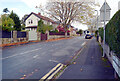
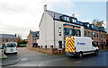
3
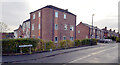
Nora Avenue, Knaresborough
The taller building in the centre stands on the site of the former Ivy Cottage pub.
Image: © habiloid
Taken: 28 Oct 2020
0.05 miles
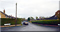
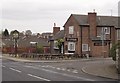
4
The Ivy Cottage, Stockwell Lane, Knaresborough
Image: © habiloid
Taken: 26 May 2012
0.05 miles
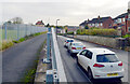
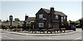
6
The Ivy Cottage, Knaresborough
The pub is at the corner of Stockwell Lane and Nora Avenue.
Image: © Derek Harper
Taken: 3 Apr 2012
0.05 miles
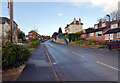
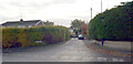
8
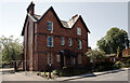
Old Holly Bank Children's Home, Stockwell Lane, Knaresborough
Image: © habiloid
Taken: 26 May 2012
0.07 miles