IMAGES TAKEN NEAR TO
Middleton Quernhow, RIPON, HG4 5HX
Introduction
This page details the photographs taken nearby to HG4 5HX by members of the Geograph project.
The Geograph project started in 2005 with the aim of publishing, organising and preserving representative images for every square kilometre of Great Britain, Ireland and the Isle of Man.

There are currently over 7.5m images from over14,400 individuals and you can help contribute to the project by visiting https://www.geograph.org.uk
Image Map
Images are licensed for reuse under creativecommons.org/licenses/by-sa/2.0
Notes
- Clicking on the map will re-center to the selected point.
- The higher the marker number, the further away the image location is from the centre of the postcode.
Image Listing (21 Images Found)
Images are licensed for reuse under creativecommons.org/licenses/by-sa/2.0
Image
Details
Distance
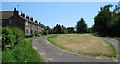
1

Middleton Quernhow
As the daffodils fade, they are replaced by dandelions on the green at Middleton Quernhow.
Image: © Gordon Hatton
Taken: 9 May 2010
0.02 miles
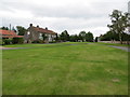
2
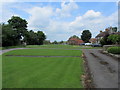
Middleton Quernhow
Looking north over the green, Middleton Quernhow
Image: © Chris Heaton
Taken: 1 Jun 2014
0.02 miles
3
Middleton Quernhow
Digby Cayley was Lord of the Manor here in the 19th century (White's Directory 1840).
Image: © David Rogers
Taken: 1 Jun 2009
0.03 miles
4
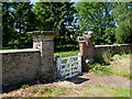
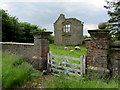
Middleton Quernhow Hall
Grade II listed wall and gate piers at the ruined Old Hall.
Image: © David Rogers
Taken: 1 Jun 2009
0.04 miles
6
Middleton Quernhow Hall
It was already being referred to as Old Hall as early as 1856. Now Grade II listed. Apparently the "township" used to belong to the Herberts, to one of whom, Sir Thomas Herbert, Charles I, a short time before his execution in 1649, presented a silver clock as a testimony of his royal favour.
Image: © David Rogers
Taken: 1 Jun 2009
0.06 miles
7

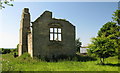
Middleton Quernhow Hall
The slight remains of the 17th century manor house at Middleton Quernhow.
Image: © Gordon Hatton
Taken: 9 May 2010
0.06 miles
8
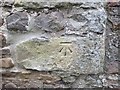
Ordnance Survey Cut Mark
This mark can be found on the roadside wall of a building at The Manor, Middleton Quernhow. The benchmark's recorded height is 37.825 metres above sea level.
For more detail see : https://www.bench-marks.org.uk/bm108692
Image: © Peter Wood
Taken: 15 Jun 2019
0.07 miles
9
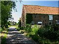
Middleton Quernhow
View of the Old Hall from Coldstone Lane.
Image: © David Rogers
Taken: 1 Jun 2009
0.07 miles
10
The Old Hall in Middleton Quernhow
The house was originally built in the early part of the 17th century, and by the early 20th century it was still complete although roofless.
Since then it has slowly fallen into disrepair, despite being a Grade II Listed Building.
Image: © Chris Heaton
Taken: 1 Jun 2014
0.07 miles