IMAGES TAKEN NEAR TO
High Ellington, RIPON, HG4 4PP
Introduction
This page details the photographs taken nearby to HG4 4PP by members of the Geograph project.
The Geograph project started in 2005 with the aim of publishing, organising and preserving representative images for every square kilometre of Great Britain, Ireland and the Isle of Man.

There are currently over 7.5m images from over14,400 individuals and you can help contribute to the project by visiting https://www.geograph.org.uk
Image Map
Images are licensed for reuse under creativecommons.org/licenses/by-sa/2.0
Notes
- Clicking on the map will re-center to the selected point.
- The higher the marker number, the further away the image location is from the centre of the postcode.
Image Listing (8 Images Found)
Images are licensed for reuse under creativecommons.org/licenses/by-sa/2.0
Image
Details
Distance
1
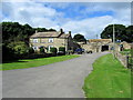
Warren House Farm
Large traditional farmhouse off Crook Lane, between Ellingstring and Fearby
Image: © Chris Heaton
Taken: 5 Sep 2012
0.01 miles
2
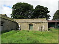
Outbuildings at Warren House
Farm outbuildings at the large copmlex of Warren House
Image: © Chris Heaton
Taken: 5 Sep 2012
0.03 miles
3
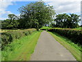
Access Drive from Warren House
Tarmaced access drive leading from Warren House Farm to Crook Lane
Image: © Chris Heaton
Taken: 5 Sep 2012
0.13 miles
4
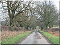
Crook Lane
Minor road heading downhill past Warren House farm towards Fearby.
Image: © Gordon Hatton
Taken: 30 Jan 2021
0.16 miles
5
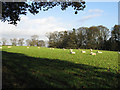
A Field Of Sheep
Near Warren House.
Image: © Roger Gilbertson
Taken: 20 Nov 2006
0.16 miles
6
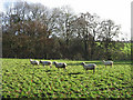
Only One Was Curious
Sheep near Warren House.
Image: © Roger Gilbertson
Taken: 20 Nov 2006
0.16 miles
7
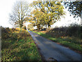
The Road To High Ellington
At Warren House Farm.
Image: © Roger Gilbertson
Taken: 20 Nov 2006
0.16 miles
8
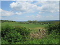
Crook Lane view
Looking east from Crook Lane.
Image: © T Eyre
Taken: 23 May 2023
0.19 miles