IMAGES TAKEN NEAR TO
Masham, RIPON, HG4 4NU
Introduction
This page details the photographs taken nearby to HG4 4NU by members of the Geograph project.
The Geograph project started in 2005 with the aim of publishing, organising and preserving representative images for every square kilometre of Great Britain, Ireland and the Isle of Man.

There are currently over 7.5m images from over14,400 individuals and you can help contribute to the project by visiting https://www.geograph.org.uk
Image Map
Images are licensed for reuse under creativecommons.org/licenses/by-sa/2.0
Notes
- Clicking on the map will re-center to the selected point.
- The higher the marker number, the further away the image location is from the centre of the postcode.
Image Listing (11 Images Found)
Images are licensed for reuse under creativecommons.org/licenses/by-sa/2.0
Image
Details
Distance
1
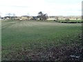
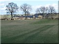
Farmland north of Fearby Road
East of the track to High Spelder Banks.
Image: © Christine Johnstone
Taken: 3 Mar 2014
0.12 miles
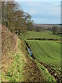
2
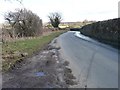
Fearby Road at the 112 metre spot height
Looking eastwards towards Masham.
Image: © Christine Johnstone
Taken: 3 Mar 2014
0.12 miles
3
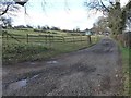
Track to High Spelder Banks
Runs northwards from Fearby Road at a 112 metre spot height.
Image: © Christine Johnstone
Taken: 3 Mar 2014
0.14 miles
4
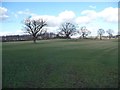
Trees crossing a field, south of Spelder Banks Plantation
Possibly the remains of a former field boundary.
Image: © Christine Johnstone
Taken: 3 Mar 2014
0.16 miles
5
Trees on a field boundary
South-east of Spelder Banks Plantation.
Image: © Christine Johnstone
Taken: 3 Mar 2014
0.17 miles
6
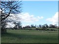
Sheep pasture with issues and sinks
Between Fearby Road and High Spelder Banks.
Image: © Christine Johnstone
Taken: 3 Mar 2014
0.18 miles
7
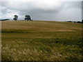
Large Field near Micklebury Farm
Barley sways in the breeze to the tune of a west wind - a crop perhaps destined for the nearby breweries of Masham.
Image: © Chris Heaton
Taken: 28 Jul 2009
0.22 miles
8
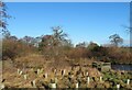
Wetland area west of Masham
This appears to have been created on the line of Alder Beck, but are the wooden screens for the benefit of bird watchers or duck shooters?
Image: © Gordon Hatton
Taken: 25 Jan 2021
0.22 miles
9

Low farm sheds, High Spelder Banks
Hen-houses, I think.
Image: © Christine Johnstone
Taken: 3 Mar 2014
0.23 miles
10
Path towards Masham
This is path number 15.89/2 heading east from Micklebury lane towards Masham. The path is part of the Ripon Rowel circuit.
Image: © Gordon Hatton
Taken: 25 Jan 2021
0.24 miles