IMAGES TAKEN NEAR TO
Fearby Cross, RIPON, HG4 4NE
Introduction
This page details the photographs taken nearby to Fearby Cross, HG4 4NE by members of the Geograph project.
The Geograph project started in 2005 with the aim of publishing, organising and preserving representative images for every square kilometre of Great Britain, Ireland and the Isle of Man.

There are currently over 7.5m images from over14,400 individuals and you can help contribute to the project by visiting https://www.geograph.org.uk
Image Map (Loading...)


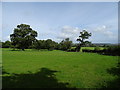
Getting Data...Please wait
Leaflet Map data © OpenStreetMap
Images are licensed for reuse under creativecommons.org/licenses/by-sa/2.0
Notes
- Clicking on the map will re-center to the selected point.
- The higher the marker number, the further away the image location is from the centre of the postcode.
Image Listing (22 Images Found)
Images are licensed for reuse under creativecommons.org/licenses/by-sa/2.0
Image
Details
Distance
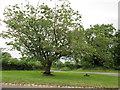
1
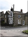
Cottages at Fearby Cross
On the south side of the triangle of grass.
Image: © Christine Johnstone
Taken: 3 Mar 2014
0.01 miles
2
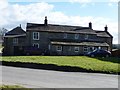
The Kings Head, Fearby
Although the pub sign is still on the gable end, the Kings Head has been closed since 2004 and shows no sign of reopening.
Image: © Gordon Hatton
Taken: 16 Mar 2008
0.02 miles
3
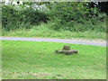
Fearby Cross base and stump
At the eastern end of the village
Image: © Martin Dawes
Taken: 14 Jul 2014
0.02 miles
4
Fearby Cross, remains of,
On an island at the eastern end of this long village
Image: © Martin Dawes
Taken: 14 Jul 2014
0.02 miles
5
![Fearby Cross [remains of]](https://s0.geograph.org.uk/geophotos/03/87/70/3877020_1b77e26b_120x120.jpg)
Fearby Cross [remains of]
A stone stump in a triangle of grass at the crossroads. For more information, see http://megalithix.wordpress.com/2009/11/23/fearby-cross/ .
Image: © Christine Johnstone
Taken: 3 Mar 2014
0.02 miles
6
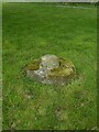
Old Wayside Cross in Fearby
Fearby Cross, the old base and stump of shaft of a Wayside Cross. Set on a grass triangle at the junction of Fearby Road and Mossra Lane in Fearby parish. Grade II Listed https://historicengland.org.uk/listing/the-list/list-entry/1301277. See also http://megalithix.wordpress.com/2009/11/23/fearby-cross/ and https://www.geograph.org.uk/photo/4081919.
Milestone Society National ID: YNHG_FEA
Image: © Mike Rayner
Taken: 24 Apr 2022
0.03 miles
7
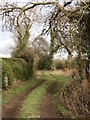
A promising path
This path, heading down Dawsons Lane from Fearby starts promisingly, but soon degenerates into a tangle of undergrowth. You have been warned.
Image: © Gordon Hatton
Taken: 16 Mar 2008
0.09 miles
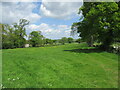
9
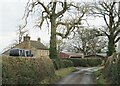
Lane at Carter Ings farm
Just ahead of the house is the junction with Sutton Lane, a very narrow road where it would be inadvisable to meet a tractor coming the other way.
Image: © Gordon Hatton
Taken: 30 Jan 2021
0.15 miles