IMAGES TAKEN NEAR TO
Masham, RIPON, HG4 4JF
Introduction
This page details the photographs taken nearby to HG4 4JF by members of the Geograph project.
The Geograph project started in 2005 with the aim of publishing, organising and preserving representative images for every square kilometre of Great Britain, Ireland and the Isle of Man.

There are currently over 7.5m images from over14,400 individuals and you can help contribute to the project by visiting https://www.geograph.org.uk
Image Map
Images are licensed for reuse under creativecommons.org/licenses/by-sa/2.0
Notes
- Clicking on the map will re-center to the selected point.
- The higher the marker number, the further away the image location is from the centre of the postcode.
Image Listing (6 Images Found)
Images are licensed for reuse under creativecommons.org/licenses/by-sa/2.0
Image
Details
Distance
1
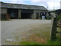
Hammer Farm
Storage buildings at Hammer Farm
Image: © William Metcalfe
Taken: 7 Jul 2007
0.05 miles
2
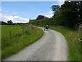
Walkers
Three walkers on a blustery July day, heading on a bridleway towards Hammer Farm.
Image: © William Metcalfe
Taken: 7 Jul 2007
0.07 miles
3
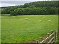
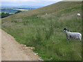
Sheep grazing
Grey Yaud Plantation is in the background.
Image: © William Metcalfe
Taken: 7 Jul 2007
0.07 miles
4
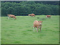
Grazing cattle
Grey Yaud Plantation provides the backcloth for these animals.
Image: © William Metcalfe
Taken: 7 Jul 2007
0.09 miles
5
Sheep
Although the farm has both sheep and cattle, the former are relegated to this more barren pasture.
Image: © William Metcalfe
Taken: 7 Jul 2007
0.16 miles
6
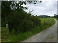
Bridleway
Bridleway leading to Hammer Farm at the point it enters the grid square.
Image: © William Metcalfe
Taken: 7 Jul 2007
0.24 miles