IMAGES TAKEN NEAR TO
Masham, RIPON, HG4 4DH
Introduction
This page details the photographs taken nearby to HG4 4DH by members of the Geograph project.
The Geograph project started in 2005 with the aim of publishing, organising and preserving representative images for every square kilometre of Great Britain, Ireland and the Isle of Man.

There are currently over 7.5m images from over14,400 individuals and you can help contribute to the project by visiting https://www.geograph.org.uk
Image Map (Loading...)


Getting Data...Please wait
Leaflet Map data © OpenStreetMap
Images are licensed for reuse under creativecommons.org/licenses/by-sa/2.0
Notes
- Clicking on the map will re-center to the selected point.
- The higher the marker number, the further away the image location is from the centre of the postcode.
Image Listing (16 Images Found)
Images are licensed for reuse under creativecommons.org/licenses/by-sa/2.0
Image
Details
Distance
1
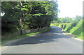
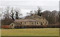
Looking towards North Cote Farm
The public footpath from Masham Bridge to the A6108 near North Cote Cottage I found difficult to follow, the course having being slightly altered. I was hoping to follow the dismantled railway to West Tanfield, but discovered it was badly overgrown and prohibited to public access - which seems an awful waste of a leisure resource.
The photograph looks along the edge of a field boundary towards North Cote Farm.
Image: © Chris Heaton
Taken: 2 May 2012
0.07 miles
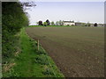
3
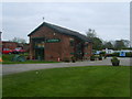
Masham railway station site, Yorkshire
Opened in 1875 by the North Eastern Railway at the end of a short branch off the Leeds-Harrogate-Northallerton railway line at Melmerby, this station closed to passengers in 1931, long before Dr. Beeching. It continued for goods until 1963. Forecourt, with old goods shed to the right.
Image: © Nigel Thompson
Taken: 21 Sep 2008
0.14 miles
4
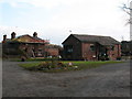
The Old Station
At Low Burton. The terminus of the Melmerby to Masham branch. Now a Caravan Park. The building in the photograph is the former goods shed, now a cafe and art gallery. Photographs of the station before and after closure can be found at http://www.disused-stations.org.uk/m/masham/index.shtml together with a history of the branch line.
Image: © Michael Graham
Taken: 2 May 2010
0.14 miles
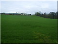
5
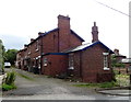
Former station site, Masham
Buildings associated with the former railway station at Masham. Now the entrance to a holiday park and including an excellent cafe, housed in the former goods shed right centre of picture. The original station building is on the left and now a private house. Photos of the station before and after closure and information on the branch line can be found at http://www.disused-stations.org.uk/m/masham/index.shtml
Image: © Gordon Hatton
Taken: 16 Nov 2007
0.15 miles
6
Former railway station, Masham
The Masham branch line closed in 1963.
Image: © JThomas
Taken: 5 Sep 2020
0.16 miles
7
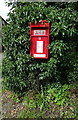
Elizabeth II postbox on the A6108, Masham
Postbox No. HG4 66.
See Image] for context.
Image: © JThomas
Taken: 5 Sep 2020
0.18 miles
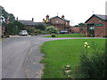
8
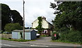
Cottages on the A6108, Masham
Showing position of Postbox No. HG4 66.
See Image] for context.
Image: © JThomas
Taken: 5 Sep 2020
0.18 miles
9
The Old Mill, Masham
Grade II listed former Masham Corn Mill, on the banks of the River Ure.
Image: © David Rogers
Taken: 16 Mar 2013
0.19 miles