IMAGES TAKEN NEAR TO
Kirkby Road, RIPON, HG4 3RU
Introduction
This page details the photographs taken nearby to Kirkby Road, HG4 3RU by members of the Geograph project.
The Geograph project started in 2005 with the aim of publishing, organising and preserving representative images for every square kilometre of Great Britain, Ireland and the Isle of Man.

There are currently over 7.5m images from over14,400 individuals and you can help contribute to the project by visiting https://www.geograph.org.uk
Image Map
Images are licensed for reuse under creativecommons.org/licenses/by-sa/2.0
Notes
- Clicking on the map will re-center to the selected point.
- The higher the marker number, the further away the image location is from the centre of the postcode.
Image Listing (40 Images Found)
Images are licensed for reuse under creativecommons.org/licenses/by-sa/2.0
Image
Details
Distance
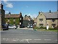
1
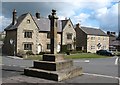
Kirkby Malzeard market cross
The cross itself does not appear to be of any great age, but the market charter dates back over 700 years. West of the cross [shown better in Chris Heaton's photo] are a group of buildings which occupy the area that was once the market place. Kirkby was an important market and administration centre in the middle ages and for a long period [until the 18thC] it was the main market centre for an area stretching across the moors from Nidderdale to lower Wensleydale. Both Fountains and Byland Abbeys held land nearby, whilst market roads headed across the moors towards Pateley Bridge and upper Nidderdale.
Image: © Gordon Hatton
Taken: 14 Apr 2008
0.03 miles
2
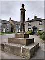
Old Wayside Cross in Kirkby Malzeard
The Market Cross, the old shaft and base of a central cross in a new cross. Set on the northwest side of the junction of Main Street and Church Street in Kirkby Malzeard parish. Grade II Listed https://historicengland.org.uk/listing/the-list/list-entry/1150472. See also http://www.geograph.org.uk/photo/762918 and http://www.geograph.org.uk/photo/186244.
Milestone Society National ID: YNHG_KIR01
Image: © H Jones
Taken: 27 Apr 2023
0.03 miles
4
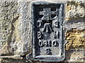
Ordnance Survey Flush Bracket S0410
This can be found on the wall of the former Police Station - now a private dwelling.
For more detail see : http://www.bench-marks.org.uk/bm11375
Image: © Peter Wood
Taken: 2 Sep 2014
0.04 miles
5
looking across to Church Street, Kirkby Malzeard
Image: © Ian S
Taken: 24 Jul 2011
0.04 miles
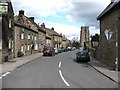
6
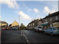
Main Street Kirkby Malzeard
Turn left for the church
Image: © Martin Dawes
Taken: 11 Nov 2016
0.04 miles
7
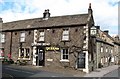
The Queens Head
One of two pubs in the village, this one stands on the corner of Church Street close to the market cross.
Image: © Gordon Hatton
Taken: 14 Apr 2008
0.04 miles
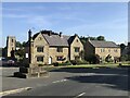
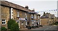
8
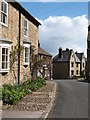
A corner of Kirkby Malzeard
Kirkby is an attractive village with many houses built to a local style in sandstone.
Image: © Gordon Hatton
Taken: 14 Apr 2008
0.04 miles
9
The Queen's Head Inn - Kirkby Malzeard
Image: © Anthony Parkes
Taken: 25 May 2019
0.04 miles
10
Church Street, Kirkby Malzeard
Sturdy village houses in a variety of styles line the way to the church. The local building material is almost entirely sandstone.
Image: © Gordon Hatton
Taken: 14 Apr 2008
0.05 miles