IMAGES TAKEN NEAR TO
Dallowgill, RIPON, HG4 3QX
Introduction
This page details the photographs taken nearby to Dallowgill, HG4 3QX by members of the Geograph project.
The Geograph project started in 2005 with the aim of publishing, organising and preserving representative images for every square kilometre of Great Britain, Ireland and the Isle of Man.

There are currently over 7.5m images from over14,400 individuals and you can help contribute to the project by visiting https://www.geograph.org.uk
Image Map (Loading...)


Getting Data...Please wait
Leaflet Map data © OpenStreetMap
Images are licensed for reuse under creativecommons.org/licenses/by-sa/2.0
Notes
- Clicking on the map will re-center to the selected point.
- The higher the marker number, the further away the image location is from the centre of the postcode.
Image Listing (8 Images Found)
Images are licensed for reuse under creativecommons.org/licenses/by-sa/2.0
Image
Details
Distance
1
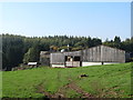
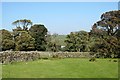
Potter Lane Farm
Upland farm situated at 250m on the eastern edge of the Pennine moors. On this side of Dallowgill there is improved grassland, but the far side is mostly moorland above the level of the forestry plantations.
Image: © Gordon Hatton
Taken: 10 Oct 2018
0.01 miles
2
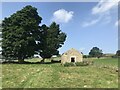
Farm track below Potter Lane Farm
The OS map suggests a ford across the beck here, but there is a bridge. However one will not escape dryshod as there is plenty of liquid mud to negotiate when opening the gate. This is also the start of a path across the moor to Kettlestang shooting house. In his book 'Green Roads in the Mid Pennines', Arthur Raistrick suggests that this may have been an ancient trackway across the moors to Sigsworth and down to Gouthwaite in Nidderdale. There is also the suggestion that parts of it were paved and that the stones may have been removed when the moorland walls were constructed in the 19thC. Having walked the route from Kettestang to Potter Lane Farm, the only advice I can give is don't try it!
Image: © Gordon Hatton
Taken: 10 Oct 2018
0.04 miles
4
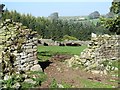
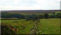
Cattle through the gap
Cattle in pastureland on the south side of Dallowgill. The OS map shows the path heading downhill and keeping this side of the wall [despite the farm gate seen across the field]. One can expect trouble at the bottom of the field as there is no obvious stile or gap, an inelegant scramble over a wall and down a steep slope being necessary. Probably better to brave the cattle and head for the gate.
Image: © Gordon Hatton
Taken: 10 Oct 2018
0.14 miles
5
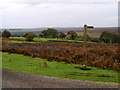
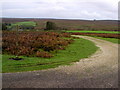
Easier times ahead?
The 'path' over the moor from Kettlestang Shooting House eventually meets improved grassland and a gate that actually opens. Weary travellers, already caked in peat from the moorland bogs should not cheer just yet as the easily opened gate has water running under it and 20m of squelch the other side, whilst further down the hill is a non existent wall stile followed by a mud bath down by the beck. An enjoyable walk.
Image: © Gordon Hatton
Taken: 10 Oct 2018
0.18 miles
8
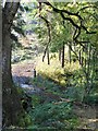
Footpath to Potter Lane Farm
Sunken path heading towards Potter Lane Farm on the edge of Dallowgill Moor.
Image: © Gordon Hatton
Taken: 5 Oct 2009
0.24 miles