IMAGES TAKEN NEAR TO
Ringbeck Road, RIPON, HG4 3QH
Introduction
This page details the photographs taken nearby to Ringbeck Road, HG4 3QH by members of the Geograph project.
The Geograph project started in 2005 with the aim of publishing, organising and preserving representative images for every square kilometre of Great Britain, Ireland and the Isle of Man.

There are currently over 7.5m images from over14,400 individuals and you can help contribute to the project by visiting https://www.geograph.org.uk
Image Map (Loading...)


Getting Data...Please wait
Leaflet Map data © OpenStreetMap
Images are licensed for reuse under creativecommons.org/licenses/by-sa/2.0
Notes
- Clicking on the map will re-center to the selected point.
- The higher the marker number, the further away the image location is from the centre of the postcode.
Image Listing (6 Images Found)
Images are licensed for reuse under creativecommons.org/licenses/by-sa/2.0
Image
Details
Distance
1
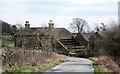
Approaching Bagwith House
A Dales edge farm house that appears to be in the process of being 'done up', judging by the work in progress.
Image: © Gordon Hatton
Taken: 14 Mar 2018
0.02 miles
2
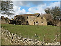
Stock Beck House
Stock Beck House is the name given to this dilapidated building on the 1:25000 map. At first it appears to be just a decaying barn, but the right hand side was once a dwelling. Perhaps the oddest feature is the use of clay tiles for the roof, as this is on the edge of the moor in gritstone country. Tiled roofs are more likely to be found in the vale some 10 miles further east.
Image: © Gordon Hatton
Taken: 10 Mar 2009
0.21 miles
3
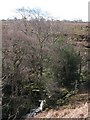
Stock Beck
A modest waterfall on Stock Beck at the point where it is crossed by the Ripon Rowell footpath. The beck is one of the main feeder streams for the River Laver which flows east to join the Skell on the edge of Ripon.
Image: © Gordon Hatton
Taken: 10 Mar 2009
0.22 miles
4
Stock Wath Public House
Although known to most as Stock Beck Farm, on the 1st Ed. OS Map of 1850, this was an old drovers' inn on one of the roads over from Lofthouse in Upper Nidderdale to the market at Kirkby Malzeard.
Stock Wath was a ford through Stock Beck, which can now be crossed via a wooden bridge.
Image: © Matthew Hatton
Taken: 23 Apr 2020
0.22 miles
5
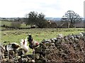
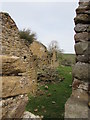
Residents of Stock Beck House
Looking back through entries on 'Geograph' I note that I photographed this ruin in 2009 when it still had a roof. Now in a much worse state of decay, although the resident poultry don't seem to mind. There's always a flock of chickens here, and one wonders who takes care of them as farm houses are some distance away.
Image: © Gordon Hatton
Taken: 14 Mar 2018
0.24 miles
6
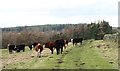
Tread carefully past the bull
Big brown bull by the footpath. Fortunately he was more interested in his harem of cows than the passing walker. Bulls of certain breeds are allowed in fields where there are paths if they are under a certain age [ask first] or are with cows. Dairy bulls such as Holstein are considered too dangerous to be allowed near paths - maybe they can run faster!
Image: © Gordon Hatton
Taken: 14 Mar 2018
0.25 miles