IMAGES TAKEN NEAR TO
Ripon Road, RIPON, HG4 3QE
Introduction
This page details the photographs taken nearby to Ripon Road, HG4 3QE by members of the Geograph project.
The Geograph project started in 2005 with the aim of publishing, organising and preserving representative images for every square kilometre of Great Britain, Ireland and the Isle of Man.

There are currently over 7.5m images from over14,400 individuals and you can help contribute to the project by visiting https://www.geograph.org.uk
Image Map
Images are licensed for reuse under creativecommons.org/licenses/by-sa/2.0
Notes
- Clicking on the map will re-center to the selected point.
- The higher the marker number, the further away the image location is from the centre of the postcode.
Image Listing (9 Images Found)
Images are licensed for reuse under creativecommons.org/licenses/by-sa/2.0
Image
Details
Distance
1
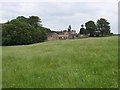
North Close Farm
Farm in an area called North Park, near Kirkby Malzeard
Image: © Chris Heaton
Taken: 13 Jun 2006
0.05 miles
2
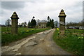
Entrance to North Close Farm
This photograph was taken from the road about 1000m east of Kirkby Malzeard village.
Image: © David Rogers
Taken: 7 Apr 2008
0.11 miles
3
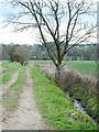
Farm track by a tiny beck
This little beck seems hardly more than a ditch and doesn't warrant a name on old six inch maps.
Image: © Gordon Hatton
Taken: 30 Apr 2021
0.16 miles
4
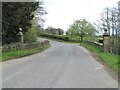
Creets Bridge
On the road out of Kirkby Malzeard on the way to Ripon. Late 18th century and grade 2 listed.
Image: © Gordon Hatton
Taken: 30 Apr 2021
0.20 miles
5
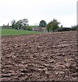
Difficult terrain, North Pasture
On the line of the footpath near Grover Dale farm. Recent ploughing has made progress very difficult, although no more tricky than the next field which contains 6 bulls, all of which are capable of reaching the stile in the corner 2 seconds quicker than any walker [or runner].
Image: © Gordon Hatton
Taken: 6 May 2012
0.20 miles
6

Bridge near Kirkby Malzeard
Creets Bridge, which carries the road over Kex Beck, is a single-arch late C18th bridge, rebuilt after flooding in 2000 (Image]). Grade II listed.
Image: © Stephen Richards
Taken: 15 May 2013
0.20 miles
7
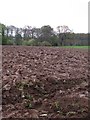
Difficult footpath, North Park
Looking along the line of the footpath at North Park, Kirkby Malzeard. Recent ploughing has made the route difficult to use.
Image: © Gordon Hatton
Taken: 6 May 2012
0.21 miles
8
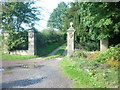
Entrance to Mowbray Castle
Ornamental Entrance to the site of Mowbray Castle, Kirkby Malzeard. This gateway is passed on the Aislabie Walk from Fountains Abbey.
Image: © John Sparshatt
Taken: 18 Sep 2012
0.22 miles
9
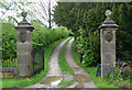
Gate piers near Kirkby Malzeard
With ball finials and a coat of arms on each pier, perhaps once connected to Mowbray Castle? They don't look particularly old and are not listed.
Image: © Stephen Richards
Taken: 15 May 2013
0.22 miles