IMAGES TAKEN NEAR TO
Sutton Grange, RIPON, HG4 3JY
Introduction
This page details the photographs taken nearby to HG4 3JY by members of the Geograph project.
The Geograph project started in 2005 with the aim of publishing, organising and preserving representative images for every square kilometre of Great Britain, Ireland and the Isle of Man.

There are currently over 7.5m images from over14,400 individuals and you can help contribute to the project by visiting https://www.geograph.org.uk
Image Map (Loading...)


Getting Data...Please wait
Leaflet Map data © OpenStreetMap
Images are licensed for reuse under creativecommons.org/licenses/by-sa/2.0
Notes
- Clicking on the map will re-center to the selected point.
- The higher the marker number, the further away the image location is from the centre of the postcode.
Image Listing (7 Images Found)
Images are licensed for reuse under creativecommons.org/licenses/by-sa/2.0
Image
Details
Distance
1
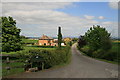
Red House Farm
Entrance to Red House Farm on Kirkby Road.
Image: © David Rogers
Taken: 15 May 2008
0.01 miles
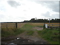
2
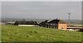
Red House Farm
View across the farm buildings from the nearby bridleway.
Image: © Gordon Hatton
Taken: 30 Dec 2007
0.02 miles
5
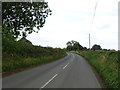
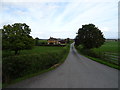
Minor road near Red House Farm
Towards Ripon.
Image: © JThomas
Taken: 12 Sep 2020
0.16 miles
7
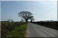
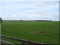
Along Kirkby Road
Looking along Kirkby Road towards Ripon.
Image: © DS Pugh
Taken: 31 Mar 2021
0.22 miles