IMAGES TAKEN NEAR TO
North Stainley, RIPON, HG4 3JN
Introduction
This page details the photographs taken nearby to HG4 3JN by members of the Geograph project.
The Geograph project started in 2005 with the aim of publishing, organising and preserving representative images for every square kilometre of Great Britain, Ireland and the Isle of Man.

There are currently over 7.5m images from over14,400 individuals and you can help contribute to the project by visiting https://www.geograph.org.uk
Image Map (Loading...)


Getting Data...Please wait
Leaflet Map data © OpenStreetMap
Images are licensed for reuse under creativecommons.org/licenses/by-sa/2.0
Notes
- Clicking on the map will re-center to the selected point.
- The higher the marker number, the further away the image location is from the centre of the postcode.
Image Listing (5 Images Found)
Images are licensed for reuse under creativecommons.org/licenses/by-sa/2.0
Image
Details
Distance
1
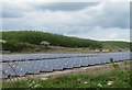
Solar panels at Potgate
Chris Heaton photographed decaying poultry houses here back in 2006, but these have been cleared and the whole area is now covered in solar panels which presumably make more money than chickens. The bank in the background forms the edge of extensive limestone quarries.
Image: © Gordon Hatton
Taken: 13 May 2020
0.07 miles
2
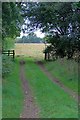
Private Road to Potgate Farm
But Public Bridleway to North Stainley.
Image: © Mick Garratt
Taken: 31 Aug 2011
0.14 miles
3
Abandoned Batteries at Potgate Farm
This eyesore is what remains of Potgate Farm - crumbling chicken batteries left to the elements
Image: © Chris Heaton
Taken: 13 Jun 2006
0.16 miles
4
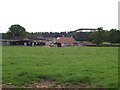
New Zealand Farm
Farm set in countryside north west of Ripon. If you are wondering what that structure is behind, let me put your curiosity at rest - it is part of a rollercoaster called the "Ultimate" and belongs to the rapidly expanding theme park of Lightwater Valley.
Image: © Chris Heaton
Taken: 13 Jun 2006
0.16 miles