IMAGES TAKEN NEAR TO
Sawley, RIPON, HG4 3EZ
Introduction
This page details the photographs taken nearby to HG4 3EZ by members of the Geograph project.
The Geograph project started in 2005 with the aim of publishing, organising and preserving representative images for every square kilometre of Great Britain, Ireland and the Isle of Man.

There are currently over 7.5m images from over14,400 individuals and you can help contribute to the project by visiting https://www.geograph.org.uk
Image Map (Loading...)


Getting Data...Please wait
Leaflet Map data © OpenStreetMap
Images are licensed for reuse under creativecommons.org/licenses/by-sa/2.0
Notes
- Clicking on the map will re-center to the selected point.
- The higher the marker number, the further away the image location is from the centre of the postcode.
Image Listing (6 Images Found)
Images are licensed for reuse under creativecommons.org/licenses/by-sa/2.0
Image
Details
Distance
1
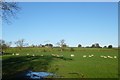
Sheep off Sawley Moor Lane
Near Sawley Moor House Farm.
Image: © DS Pugh
Taken: 27 Dec 2015
0.09 miles
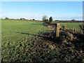
3
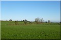
Farmland off Sawley Moor Lane
Fields between Middle Ridge Farm and Picking Gill.
Image: © DS Pugh
Taken: 27 Dec 2015
0.11 miles
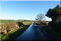
4
Looking along Sawley Moor Lane
Looking towards the corner with Sawley Moor House.
Image: © DS Pugh
Taken: 27 Dec 2015
0.12 miles
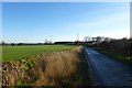
5
Pastures on Sawley Moor
Following the footpath beside the field boundary - although there is little evidence of its existence on the ground.
Image: © Chris Heaton
Taken: 23 Jan 2012
0.16 miles
6
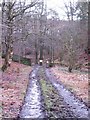
Head of Picking Gill
A track leading into Picking Gill, which becomes a deep, steep sided valley within a short distance. One suspects that the valley has been overdeepened by glacial meltwater and is one of many meltwater channels to the west of Ripon.
Image: © Gordon Hatton
Taken: 14 Feb 2011
0.19 miles