IMAGES TAKEN NEAR TO
Bramley Grange, RIPON, HG4 3DJ
Introduction
This page details the photographs taken nearby to Bramley Grange, HG4 3DJ by members of the Geograph project.
The Geograph project started in 2005 with the aim of publishing, organising and preserving representative images for every square kilometre of Great Britain, Ireland and the Isle of Man.

There are currently over 7.5m images from over14,400 individuals and you can help contribute to the project by visiting https://www.geograph.org.uk
Image Map (Loading...)


Getting Data...Please wait
Leaflet Map data © OpenStreetMap
Images are licensed for reuse under creativecommons.org/licenses/by-sa/2.0
Notes
- Clicking on the map will re-center to the selected point.
- The higher the marker number, the further away the image location is from the centre of the postcode.
Image Listing (3 Images Found)
Images are licensed for reuse under creativecommons.org/licenses/by-sa/2.0
Image
Details
Distance
1
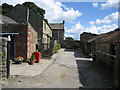
Black Hill House
Farm on the lane between Ilton and Kirkby Malzeard
Image: © Chris Heaton
Taken: 29 Aug 2006
0.10 miles
2
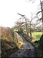
Unmade lane at Bramley Grange
One of several unmade lanes to the west of Grewelthorpe and Kirkby Malzeard. Most likely a medieval track associated with Fountains Abbey.
Image: © Gordon Hatton
Taken: 23 Dec 2007
0.13 miles
3
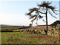
The edge of the moor
On the boundary between improved and rough grassland at 260m above sea level near Bramley Grange. The sharp eyed might just pick out the sighting tower above Roundhill Reservoir, just over 4km to the west.
Image: © Gordon Hatton
Taken: 23 Dec 2007
0.14 miles