IMAGES TAKEN NEAR TO
Studley Roger, RIPON, HG4 3BA
Introduction
This page details the photographs taken nearby to HG4 3BA by members of the Geograph project.
The Geograph project started in 2005 with the aim of publishing, organising and preserving representative images for every square kilometre of Great Britain, Ireland and the Isle of Man.

There are currently over 7.5m images from over14,400 individuals and you can help contribute to the project by visiting https://www.geograph.org.uk
Image Map (Loading...)


Getting Data...Please wait
Leaflet Map data © OpenStreetMap
Images are licensed for reuse under creativecommons.org/licenses/by-sa/2.0
Notes
- Clicking on the map will re-center to the selected point.
- The higher the marker number, the further away the image location is from the centre of the postcode.
Image Listing (12 Images Found)
Images are licensed for reuse under creativecommons.org/licenses/by-sa/2.0
Image
Details
Distance
1
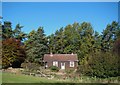
Limekiln Cottage
On Limekiln Bank near the village of Studley Roger.
Image: © David Rogers
Taken: 27 Oct 2008
0.01 miles
2
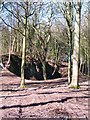
Old limestone quarry, Studley Roger
An old limestone quarry recently revealed thanks to some woodland and scrub clearance. Nearby is Lime Kiln Cottage, which suggests that there should be a kiln somewhere in this wood.
Image: © Gordon Hatton
Taken: 2 Mar 2010
0.06 miles
3
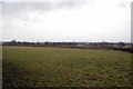
The view over Studley Roger Cricket Club towards Ripon
This wide angle shot taken from the track near the Memorial Image in the next square West, along the top of the square, is an poor attempt to show the positioning of the Cricket Club and just to its right the white line above the hedge is the Market Garden and in the trees in the distance is Ripon City
Image: © Nick W
Taken: 13 Jan 2008
0.12 miles
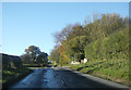
4
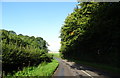
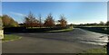
Limekiln Bank (B6265)
Towards Pateley Bridge.
Image: © JThomas
Taken: 12 Sep 2020
0.13 miles
5
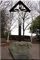
Memorial to British and Canadian soldiers of Ripon Camp
This was initially for the First World War with an addition for the Second World War
Image: © Nick W
Taken: 13 Jan 2008
0.14 miles
7
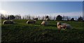
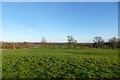
Sheep beside Studley Lane
Farmland north of Studley Roger.
Image: © DS Pugh
Taken: 1 Jan 2020
0.17 miles
8
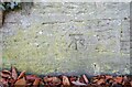
Ripon to Pateley Bridge, roadside wall
The benchmark is cut into the north facing roadside wall of B6265, and to the east of the junction to the village Studley Roger.
Image: © Mel Towler
Taken: 12 Nov 2022
0.18 miles
9
Ripon to Pateley Bridge road
There is a benchmark cut into the north facing roadside wall of B6265, and to the east of the junction to the village Studley Roger.
Image: © Mel Towler
Taken: 12 Nov 2022
0.18 miles
10
Parkland near Studley Roger
Looking east from Studley Lane.
Image: © DS Pugh
Taken: 27 Dec 2015
0.21 miles