IMAGES TAKEN NEAR TO
Ash Bank Road, RIPON, HG4 2QP
Introduction
This page details the photographs taken nearby to Ash Bank Road, HG4 2QP by members of the Geograph project.
The Geograph project started in 2005 with the aim of publishing, organising and preserving representative images for every square kilometre of Great Britain, Ireland and the Isle of Man.

There are currently over 7.5m images from over14,400 individuals and you can help contribute to the project by visiting https://www.geograph.org.uk
Image Map (Loading...)


Getting Data...Please wait
Leaflet Map data © OpenStreetMap
Images are licensed for reuse under creativecommons.org/licenses/by-sa/2.0
Notes
- Clicking on the map will re-center to the selected point.
- The higher the marker number, the further away the image location is from the centre of the postcode.
Image Listing (24 Images Found)
Images are licensed for reuse under creativecommons.org/licenses/by-sa/2.0
Image
Details
Distance
1
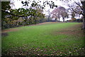
Horse field near Bishopton
There were no horses in it today. The field is by the track to the site of Bishopton Mill.
Image: © Bill Boaden
Taken: 11 Nov 2011
0.07 miles
2
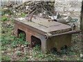
Metal Edifice from Halifax
Enormous cast iron saw bench, complete with rollers and drum for a belt drive.
Image: © Matthew Hatton
Taken: 27 Mar 2011
0.09 miles
3
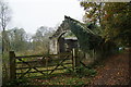
Roofless shed near the allotments
There are several allotments over to the left. The shed appears quite old but has had some partial renovation which doesn't yet extend to a roof. The track used to go to Bishopton Mill.
Image: © Bill Boaden
Taken: 11 Nov 2011
0.12 miles
5
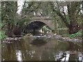
Bishopton Bridge
Sandstone bridge built over the River Laver around 1756 when the road to Pateley Bridge was turnpiked. It was widened in 1885, which can be clearly seen when standing beneath the arch. A medieval bridge here was alleged to have had a chapel on it.
Image: © Matthew Hatton
Taken: 27 Mar 2011
0.18 miles
6
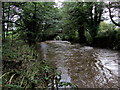
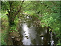
River Laver approaching the Bishopton Bridge
A swollen River Laver flows swiftly towards the outskirts of Ripon and its final destination - the confluence with the River Skell.
Image: © Chris Heaton
Taken: 16 Oct 2012
0.19 miles
7
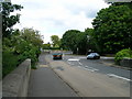
B6265 over Bishopton Bridge
The two folks walking are approximately on the gridline which runs just south of the bridge.
Image: © Matthew Hatton
Taken: 27 Mar 2011
0.19 miles
8
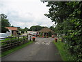
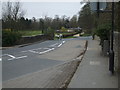
Entrance to River Laver Holiday Park
Access to this caravan and mobile home complex, from the B6265 Pateley Bridge/Ripon Road.
Image: © Chris Heaton
Taken: 25 Jul 2007
0.19 miles
9
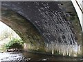
Twin skin of Bishopton Bridge
As described previously: Bishopton Bridge was built around 1756 in sandstone, this is the eastern side of the arch (the bit on the left). It was widened in 1885, the blue brick arch of the western side, the lime mortar has created small stalactites and the whitening of the bricks. The upstream side has been refaced with sandstone ashlar blocks to hide the brick arch. This bridge is Grade 2 Listed.
Image: © Matthew Hatton
Taken: 27 Mar 2011
0.19 miles