IMAGES TAKEN NEAR TO
Rowan Close, RIPON, HG4 2NS
Introduction
This page details the photographs taken nearby to Rowan Close, HG4 2NS by members of the Geograph project.
The Geograph project started in 2005 with the aim of publishing, organising and preserving representative images for every square kilometre of Great Britain, Ireland and the Isle of Man.

There are currently over 7.5m images from over14,400 individuals and you can help contribute to the project by visiting https://www.geograph.org.uk
Image Map
Images are licensed for reuse under creativecommons.org/licenses/by-sa/2.0
Notes
- Clicking on the map will re-center to the selected point.
- The higher the marker number, the further away the image location is from the centre of the postcode.
Image Listing (15 Images Found)
Images are licensed for reuse under creativecommons.org/licenses/by-sa/2.0
Image
Details
Distance
1
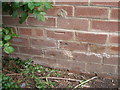
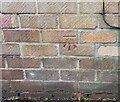
Disturbed benchmark on a building on Oak Road
Probably not good at puzzles then!
Image: © John Slater
Taken: 2 May 2012
0.03 miles
2
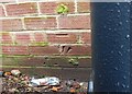
Ripon, flats on Oak Road
The damaged benchmark is cut into the north-east facing wall of flats 40 to 46 on Oak Road.
Image: © Mel Towler
Taken: 12 Jan 2023
0.03 miles
3

Ripon, flats on Oak Road
There is a damaged benchmark cut into the north-east facing wall of flats 40 to 46 on Oak Road.
Image: © Mel Towler
Taken: 12 Jan 2023
0.03 miles
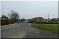
4
Lead Lane, Ripon
Viewed from Whitcliffe Lane.
Image: © Mark Anderson
Taken: 24 Jun 2012
0.10 miles
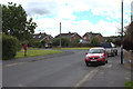
5
Junction on Whitcliffe Lane
Looking along Whitcliffe Lane at the junction with Hell Wath Lane and West Lane.
Image: © DS Pugh
Taken: 22 Dec 2021
0.13 miles
6
Ripon, 134 Whitcliffe Lane
According to the OS benchmark database there is a benchmark cut into the north-east face of the property. Nothing could be seen from the road side, although the footprint of the property remains the same.
Image: © Mel Towler
Taken: 12 Jan 2023
0.14 miles
7

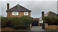
Bungalowville, Ripon
Typical of the post war development on the south side of Ripon is Southfield Road where bungalows are in the majority.
Image: © Gordon Hatton
Taken: 30 Oct 2020
0.14 miles
8
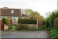
Path at the edge of town
The south western corner of Ripon where a bridleway, number 15.112/17 leaves the road corner. Only a short distance further on it becomes footpath 15.82/1, so would a cyclist or horse rider turn round at that point? An odd sort of path.
Image: © Gordon Hatton
Taken: 30 Oct 2020
0.18 miles
9
Ripon, 104 to 110, flats on Oak Road
The benchmark is cut into the north-east facing gable end of the block of flats on the south side of Oak Road.
Image: © Mel Towler
Taken: 12 Jan 2023
0.18 miles
10
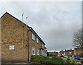
Ripon, 104-110, flats on Oak Road
There is a benchmark cut into the north-east facing gable end of the block of flats on the south side of Oak Road.
Image: © Mel Towler
Taken: 12 Jan 2023
0.18 miles