IMAGES TAKEN NEAR TO
Harrogate Road, RIPON, HG4 1SX
Introduction
This page details the photographs taken nearby to Harrogate Road, HG4 1SX by members of the Geograph project.
The Geograph project started in 2005 with the aim of publishing, organising and preserving representative images for every square kilometre of Great Britain, Ireland and the Isle of Man.

There are currently over 7.5m images from over14,400 individuals and you can help contribute to the project by visiting https://www.geograph.org.uk
Image Map (Loading...)


Getting Data...Please wait
Leaflet Map data © OpenStreetMap
Images are licensed for reuse under creativecommons.org/licenses/by-sa/2.0
Notes
- Clicking on the map will re-center to the selected point.
- The higher the marker number, the further away the image location is from the centre of the postcode.
Image Listing (18 Images Found)
Images are licensed for reuse under creativecommons.org/licenses/by-sa/2.0
Image
Details
Distance
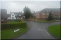
2
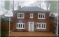
Sales and Marketing Suite, Woodland Place
Image: © N Chadwick
Taken: 30 Dec 2015
0.07 miles
3

Sales and Marketing Suite, Woodland Place
Image: © N Chadwick
Taken: 30 Dec 2015
0.08 miles
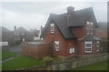
4
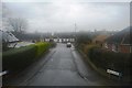
Moorside Infant School, Ripon
From a 36 bus stop, as you can probably tell, on the Harrogate Road, the former A61. Out of sight behind the school is the junior school.
Image: © Derek Harper
Taken: 22 Jun 2018
0.08 miles

7
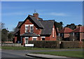
Holmefield Lodge, Ripon
Former lodge to Holmefield House on Harrogate Road.
Image: © David Rogers
Taken: 14 Mar 2011
0.12 miles
9
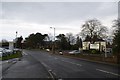
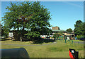
Harrogate Road
On the right is South Lodge Conservatory.
Image: © DS Pugh
Taken: 24 Jan 2016
0.17 miles