IMAGES TAKEN NEAR TO
Holmefield Crescent, RIPON, HG4 1RX
Introduction
This page details the photographs taken nearby to Holmefield Crescent, HG4 1RX by members of the Geograph project.
The Geograph project started in 2005 with the aim of publishing, organising and preserving representative images for every square kilometre of Great Britain, Ireland and the Isle of Man.

There are currently over 7.5m images from over14,400 individuals and you can help contribute to the project by visiting https://www.geograph.org.uk
Image Map (41 Images)


Getting Data...Please wait
Leaflet Map data © OpenStreetMap
Images are licensed for reuse under creativecommons.org/licenses/by-sa/2.0
Notes
- Clicking on the map will re-center to the selected point.
- The higher the marker number, the further away the image location is from the centre of the postcode.
Image Listing (41 Images Found)
Images are licensed for reuse under creativecommons.org/licenses/by-sa/2.0
Image
Details
Distance
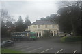
3
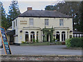
South Lodge, Ripon
Pub http://www.southlodgeripon.com/index on Harrogate Road
Image: © Paul Harrop
Taken: 10 Apr 2017
0.11 miles
4
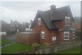
Holmefield Lodge, Ripon
Former lodge to Holmefield House on Harrogate Road.
Image: © David Rogers
Taken: 14 Mar 2011
0.11 miles
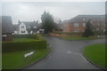
6
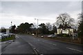
Harrogate Road
On the right is South Lodge Conservatory.
Image: © DS Pugh
Taken: 24 Jan 2016
0.12 miles
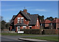
7

Lister House
A Royal British Legion Care Home.
Image: © Pauline E
Taken: 3 May 2012
0.12 miles
9

Garden of Remembrance, Lister House
A Royal British Legion Care Home.
Image: © Pauline E
Taken: 3 May 2012
0.13 miles
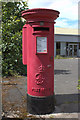
10
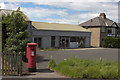
Commercial Premises To Let
Located at the junction of Whitcliffe Lane and Harrogate Road. A closer view of the postbox can be seen here: Image
Image: © Mark Anderson
Taken: 24 Jun 2012
0.14 miles