IMAGES TAKEN NEAR TO
Dallamires Lane, RIPON, HG4 1QG
Introduction
This page details the photographs taken nearby to Dallamires Lane, HG4 1QG by members of the Geograph project.
The Geograph project started in 2005 with the aim of publishing, organising and preserving representative images for every square kilometre of Great Britain, Ireland and the Isle of Man.

There are currently over 7.5m images from over14,400 individuals and you can help contribute to the project by visiting https://www.geograph.org.uk
Image Map (Loading...)


Getting Data...Please wait
Leaflet Map data © OpenStreetMap
Images are licensed for reuse under creativecommons.org/licenses/by-sa/2.0
Notes
- Clicking on the map will re-center to the selected point.
- The higher the marker number, the further away the image location is from the centre of the postcode.
Image Listing (122 Images Found)
Images are licensed for reuse under creativecommons.org/licenses/by-sa/2.0
Image
Details
Distance
1
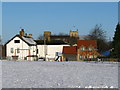
Bondgate House
In 1856 Bondgate House, painted white, was one of only a few buildings in this part of Ripon. Today Camp Close, in the foreground, remains an open play space.
Image: © David Rogers
Taken: 28 Dec 2009
0.01 miles
2
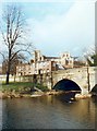
Ripon. Bridge over the Skell.
The River Skell, a stone bridge and the cathedral in the background.
Image: © Gordon Hatton
Taken: Unknown
0.03 miles
3
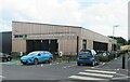
The new Ripon Leisure Centre
The Jack Laugher Leisure and Wellness Centre opened in 2022 after delays caused by gypsum problems on the site [subsidence etc]. The new centre offers a 25m, 6 lane swimming pool, plus a gym and other facilities.
Image: © Gordon Hatton
Taken: 22 Jun 2023
0.05 miles
4

Moon over Ripon Leisure Centre
A sunset over southern Ripon, seen from near Bondgate End.
Image: © Derek Harper
Taken: 27 Dec 2017
0.07 miles
5
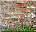
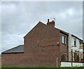
Benchmark cut into roadside wall, Ripon
The benchmark is cut into the west facing wall of Quarry Moor Lane, next to the junction with Knaresborough Road. Wider view Image]
Image: © Mel Towler
Taken: 1 Jun 2023
0.08 miles
6
Junction of Quarry Moor Lane and Knaresborough Road, Ripon
There is a benchmark cut into the west facing wall of Quarry Moor Lane, next to the junction with Knaresborough Road. Closer view Image]
Image: © Mel Towler
Taken: 1 Jun 2023
0.08 miles
7
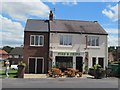
Southgate chippy
Southgate fish and chip shop seen after a recent refurbishment.
Image: © Gordon Hatton
Taken: 5 Jul 2014
0.09 miles
8
Bondgate Hall
Left of centre and listed: "Three high stone mullioned windows in each gable end" https://historicengland.org.uk/listing/the-list/list-entry/1173629 . According to https://archive.org/stream/riponmillenaryre00harr/riponmillenaryre00harr_djvu.txt , the building was involved in the "saddletree-making industry". "Here James I. is said to have taken up his quarters
when passing through Ripon on his progress to Scotland, in April, 1617, at which time " his Highness " was presented by the mayor (Simon Browne) and corporation with a gilt bowl and a pair of Ripon spurs". On the right is Ripon Pet Supplies. The road, Bondgate, is followed by NCN688.
Image: © Derek Harper
Taken: 27 Dec 2017
0.09 miles
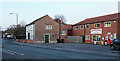
9
36 Southgate, Ripon
According to the OS benchmark database there is a cut mark on the gable end of the property. The building has been extended, which has covered the position of the benchmark.
Image: © Mel Towler
Taken: 1 Jun 2023
0.10 miles
10
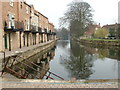
Ripon Canal
Runs 2 miles from Ripon to the junction with the River Ure at Oxclose Lock
Image: © Nigel Homer
Taken: 29 Mar 2003
0.12 miles