IMAGES TAKEN NEAR TO
Low St. Agnesgate, RIPON, HG4 1NG
Introduction
This page details the photographs taken nearby to Low St. Agnesgate, HG4 1NG by members of the Geograph project.
The Geograph project started in 2005 with the aim of publishing, organising and preserving representative images for every square kilometre of Great Britain, Ireland and the Isle of Man.

There are currently over 7.5m images from over14,400 individuals and you can help contribute to the project by visiting https://www.geograph.org.uk
Image Map (Loading...)


Getting Data...Please wait
Leaflet Map data © OpenStreetMap
Images are licensed for reuse under creativecommons.org/licenses/by-sa/2.0
Notes
- Clicking on the map will re-center to the selected point.
- The higher the marker number, the further away the image location is from the centre of the postcode.
Image Listing (536 Images Found)
Images are licensed for reuse under creativecommons.org/licenses/by-sa/2.0
Image
Details
Distance
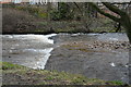
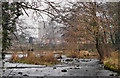
2
Silted channel by St Agnesgate, Ripon
I presume this is a former drainage channel that had a now superfluous footbridge over it.
Image: © Stephen Craven
Taken: 2 May 2016
0.01 miles
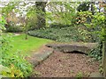
3
Former mill stream channel, Low St Agnesgate
There is an OS benchmark Image on the low wall right of the 'No Through Road' sign
Image: © Roger Templeman
Taken: 7 Jun 2013
0.02 miles
4
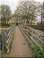
Footbridge over the river Skell
A pedestrian route from Bondgate to St Agnesgate.
Image: © Stephen Craven
Taken: 2 May 2016
0.03 miles
5
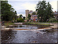
River Skell, Alma Weir
Looking over Alma Weir on the River Skell; Ripon Cathedral in the background.
Image: © David Dixon
Taken: 17 Jun 2012
0.04 miles
6
Weir has all the water gone ?
Only a small amount of water flowing in the river Skell. Not even enough to flow over the weir.
Image: © derek dye
Taken: 5 Feb 2019
0.04 miles
7
River Skell footbridge
The Cathedral peers through the mist over the River Skell at Ripon.
Image: © derek dye
Taken: 5 Feb 2019
0.04 miles
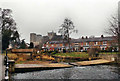
8
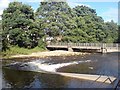
Alma Weir and Footbridge, River Skell
The weir was built in 1984 (replacing an earlier one) and includes a flow measuring station. The footbridge connects Low St Agnesgate (on the left) to Bondgate Green.
Image: © Rich Tea
Taken: 7 Jul 2007
0.04 miles
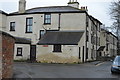
9

ER VII Postbox
In the wall of the former post office at the corner of Victoria Avenue and Priest Lane.
Image: © David Rogers
Taken: 29 May 2009
0.04 miles